Over the next few weeks development work is being undertaken to provide even more insight and free content regarding all things postcode and Aircraft noise.
New algorithms, visualisations and Web Site implementation rollout is as follows.
Description
Planned date
Status
Enhancement to the Interactive Visualisation to include a Compass filter and much improved table search.
Enhancement to the Interactive Visualisation to include a total count of flight airspace time in seconds/minutes and hours.
Mid Jan’25
LIVE
Airport scorecard and visualisation. Will include the volumes of aircraft traffic movements by; a) time of day, b) day of week am/pm and, c) volume of night flights by airport.
End Nov’24
LIVE
Upgrade to the Interactive Visualisation to include a Noise Assessment filter. I.e. the ability to only show the dates of flights where there is a likelihood of a Sleep Disturbance
End Aug’24
LIVE
Update to the House Hunter package to include 2 and 3 mile radius assessments
Mid Jun’24
LIVE
Update to the NextGen algorithms to include weightings for the new range of 2 and 3 miles Assessments.
Early Jun’24
LIVE
Upgrade to the Interactive Visualisation to include the results from the 2 Minute Assessment
19th Aug’24
LIVE
Upgrade to the Free Assessment Content page to include the 2 Minute Assessment option.
End May’24
LIVE
Introduction of the 2 minute Aircraft Postcode Assessment. The 2 minute Postcode Assessment is a free of charge offering that informs the requestor the probability of a pre-Assessed postcode being impacted by aircraft noise both at night, i.e. sleep disturbance, and during the day, i.e. loss of amenity.
Mid of May’24
LIVE
Removal of all references to pre-covid 2019 datasets. Full Assessments referring to 93 days in 2019 will be replaced with 31 Day Assessment for August 2023. This is because aircraft traffic has recovered to pre COVID levels.
All new Full Assessment requests will now analyse August 2023 aircraft movements against the current 31 day period.
We have a collective responsibility to take ownership of how our postcode airspace is being overflown by the aviation industry. Please do not assume there are existing laws to protect us, there aren’t. This UK petition will provide us with a firm footing from which to launch further initiatives relating to the management of aircraft noise and emissions and to achieve that we need public access to the facts. Let’s help make the aviation industry both accountable and responsible and prevent them from chasing us out from our homes and communities.
As UK airports expand the number of domestic and international flights will also increase but at a proportionately faster rate. As a result, more and more of our home, workplaces, schools and open spaces i.e. Postcodes, are being overflown by multiple aircraft at lower altitudes en-route to their target destination. This has become a UK nationwide issue that is touching millions of people’s lives in terms of noise and emissions and it’s getting worse, but why?
As UK airports expand the number of domestic and international flights will also increase but at a proportionately faster rate. As a result, more and more of our home, workplaces, schools and open spaces i.e. Postcodes, are being overflown by multiple aircraft at lower altitudes en-route to their target destination. This has become a UK nationwide issue that is touching millions of people’s lives in terms of noise and emissions and it’s getting worse, but why?
The actual route taken by a flight considers multiple factors, such as the plane’s altitude, speed, load, proximity to the airport and where it needs to be at a point-in-time. Every flight route over the UK mainland is determined not by the airports or airlines but by Air Traffic Controllers, who take their instruction from a government owned body called NATs.
But the routing models used by NATs are not required to include the effects of aircraft noise and noise aggregation or engine emissions by postcode. The reason is simple, Aviation is exempt from our Noise and Environment Acts i.e., there is no legal obligation for NATs to consider noise or emissions by postcode when designing or amending flight routes and patterns.
So how bad is the problem? The answer is there is no official answer. No government agency is required to collect or share flight activity by postcode. However, individual researchers like myself together with many Aircraft Campaign groups have recorded evidence that shows that hundreds of UK postcodes are subject to clusters of 9+ planes per hour, at differing altitudes and often with only a few minutes of separation. Result: a continuous wall of noise, vibration and potentially pollutants such as Carbon dioxide, Carbon monoxide, Nitrogen oxide and particulate matter such as soot.
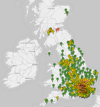
As represented by the yellow, amber and red map-pins many of the impacted postcodes are 20-35 miles out from the metropolitan cities and from the airports but the situation is often even more congested for hundreds of postcodes within cities such as London. Remember, the noise and emissions from an aircraft passing overhead will last 40-60 seconds when the flight is below 26k feet. Additionally, 50% of the flights are early morning from 4:00am, or late evening past 9:00pm, but always on a Saturday and Sunday. When have you ever been consulted about any of this?
How will knowing the flight activity numbers by postcode help? The official flight numbers will enable all of us to understand the scale and occurrences of overflying by postcode, which, if not controlled, will impact on sleep patterns, wellbeing and general health of all our families. Additionally, the same data can be used by the next generation of noise and emission models (algorithms) to determine the “best” routes through our airspace.
What if flight activity volumes numbers are not provided? The overflying of postcodes will remain uncontrolled, and no doubt get worse as the further demand for flights is satisfied through the introduction of new flight direct descent technologies. These same technologies are also designed to support the introduction of electrical passenger drones and other low level flying devices.
The requirement to publish monthly flight activity by UK postcode is simple, not onerous and is very do-able. It does not require changes to our existing laws but it will provide much needed insight into the operational management of our airspace that exists above our homes, open spaces and communities.
By sharing flight activity numbers will it not impact local house prices? The reasons for living or moving into a postcode area are complex and aircraft noise and emissions are only one of the many lifestyle factors and priorities considered. Also, like road noise, people have different levels of tolerance. So, for these reasons, we do not think house prices will be impacted by having postcode aircraft activity published on a regular basis. It is more likely to have a positive effect on house prices as people will be given the opportunity and information to actively protect their postcode communities from the Aviation industry and also the confidence to further invest in their properties.
It all sounds very sensible where do I sign? We need 100k signatures from across the nation to either mobilise the UK Government or to encourage one of the major political parties to adopt this requirement within their party ‘s manifesto.
This requirement is beyond the remit of your local MPs and it is also too big for any of the airport owners or airlines. Therefore, it’s up to us UK citizens to take ownership and drive through this proposal.
This is your petition so please do sign by clicking on the link and then we can start leading the conversation on how our airspace could and should be managed by our appointed Aviation agents. If you have further questions, then please email me at Richard.Herson@AircraftTrafficSurvey.com
* Airplane Arrivals between 7,000 and 14,000 feet.
60
Normal conversation
60-70
* Airplane Arrivals below 7,000 feet.
70
Road & Street traffic
85
Heavy traffic
90
Heavy lorries
110
Car horn
140
* Airplane taking off
* Typically the sound from an Aircraft is audible for a period of 40-50 seconds.
Note: A difference of 10 decibels is a doubling of loudness. A difference of 3 decibels is a doubling of sound Intensity. Baseline – World Health Organisation of 45 dB.
The following stats have been created by combining multiple individual Assessments to provide an understanding of what’s actually happening in our UK airspace by postcode area.
Stat 1. Based on 170+ individual postcode flight Assessments from across the UK;
46% of ‘pass-by’ flights under 20k feet occur at weekends or Mon-Fri (7.00pm to 6.00am) I.e. they can regularly be heard during family quiet times within the home.
Get involved in your airspace, sponsor an Assessment.
Stat 2. Based on 170+ individual postcode flight Assessments from across the UK;
The average time for a single flight to navigate through a local postcode airspace is 21 seconds. During this time our homes are subjected to sound waves i.e. noise and vibration and secondary noises.
Get involved and start controlling your airspace. Sponsor an Assessment.
Stat 3. Based on 170+ individual postcode flight Assessments from across the UK;
Flight activity at the major UK airports is distributed evenly over a 19 hour day (6:00 to 24:00) and also evenly across the 7 days . There is no rush hour it’s just continuous.
Get involved and start controlling your airspace. Sponsor an Assessment.
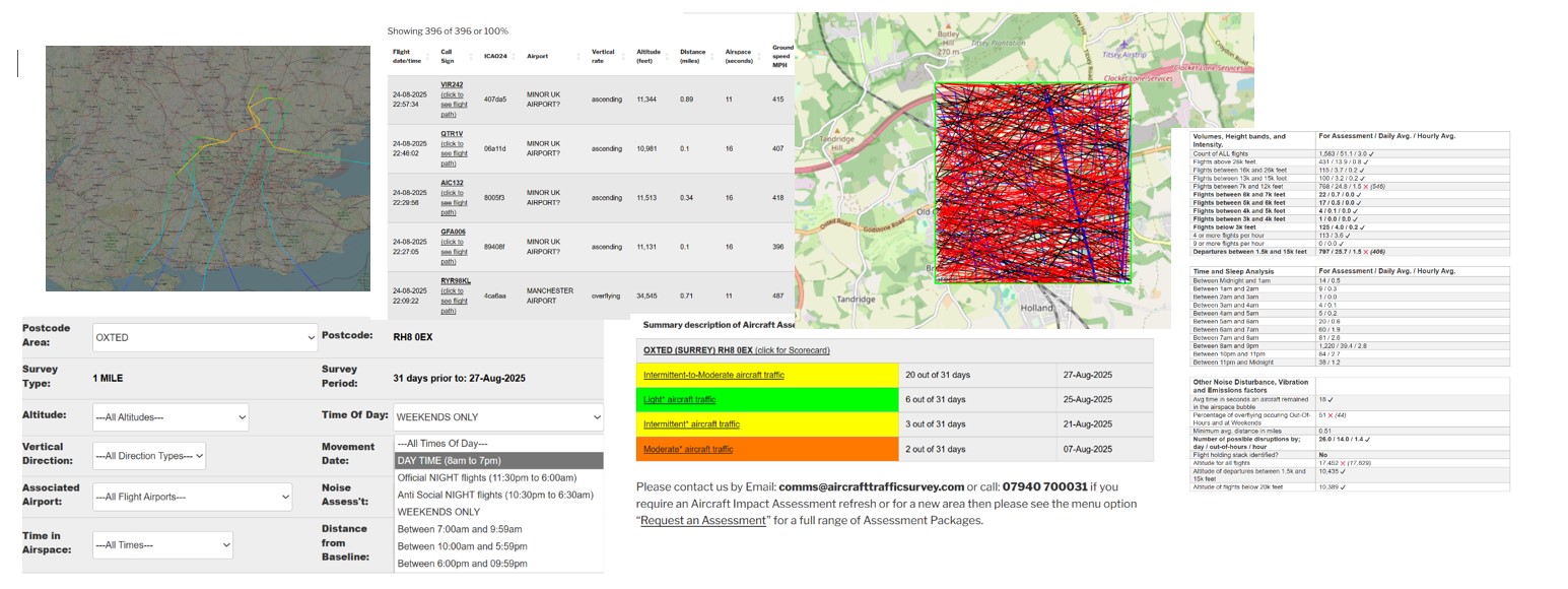
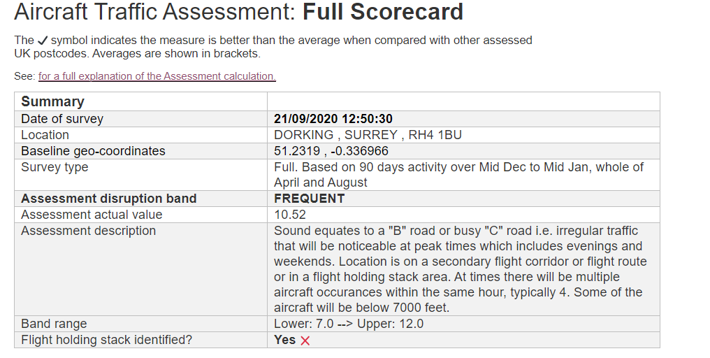
This article explains how to make sense of the information contained within the Aircraft Traffic Assessment Scorecard, both for the Full and 31 Day assessments.
Date of Survey
For the 31 Day Scorecard the date represents the end date and time for the survey. The start date and time is calculated 31 days earlier.
Whereas for the Full Scorecard the date represents when the survey was requested and is for information only.
Location
Is the identifier for the location being surveyed.
Baseline geo-coordinates
The geo-coordinates, Lat & Long, are used to define the centre of the 1 mile Assessment airspace bubble. Typically this is the actual location of the point-of-interest.
Survey Type
Describes the type of assessment survey being reported. The full survey analyses 93 days of flight events based on 2019. The 31 Day survey uses the actual survey date, see above.
Assessment disruption band
The Assessment band category e.g. FREQUENT, OCCASIONAL, VERY HIGH etc. This is an important measure.
Assessment disruption value
The actual Assessment value. Useful for gaining an understanding where the location sits within the disruption band i.e. bottom, middle or top. This is an important measure.
Assessment description
A description that attempts to relate the Assessment to an equivalent road noise.
Band range.
Shows the lower and upper levels for the Assessment band. Designed to be used in conjunction with the Assessment disruption value. This is important data.
Flight holding stack identified?
If a fight holding stack is identified the returned value is ‘YES’. Meaning planes will be held in a holding loop at between 7,000-12,000 feet. Multiple planes can exist in the stack at the same time and the planes are in “fly” mode i.e. not gliding.
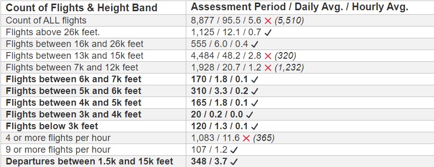
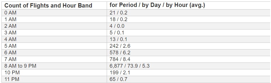
Count of ALL flights
The total number of flights that occurred within the Assessment postcode for the entire period and then averaged by day and by hour. All flights are included, however those above 35,000 feet will have little impact.
Flights above 26,000 feet
The total number of flights that occurred above 26,000 feet within the Assessment airspace. Flights between 26,000 and 35,000 feet can be heard from the ground. Flights at this height are someway from the destination airport.
Flights between 16,000 and 26,000 feet
The total number of flights that occurred between 16,000 and 26,000 feet within the assessment period. Flights at this height implies the area is being overflown and the airspace is being used by 1 or more airports.
Flights between 13,000 and 16,000 feet
As above but between 13,000 and 16,000 feet. However, the planes will be clearly heard from the ground and will be clearly visible.
Flights between 7,000 and 12,000 feet
As above but between 7,000 and 12,000 feet. This is the height that most planes are held within holding stacks prior to landing.
Flights between 6,000 and 7,000 feet
The total number of flights that occurred between 6,000 and 7,000 feet. Planes leave their holding position at this height ready for final descent.
Flights between 5,000 and 6,000 feet Flights between 4,000 and 5,000 feet Flights between 3,000 and 4,000 feet
The total number of flights that occurred between 6,000 and 3,000 feet. At this height it implies the planes have recently departed or are about to land. Both scenarios will be relatively noisy.
Flights below 3,000 feet
See above but very visual too.
4 or more flights per hour
The count of occurrences where 4 or more flights occurred within a single 60 minute period. For a flight to qualify it has to be below 26,000 feet. 4 flights within 60 minutes averages a flight every 15 minutes which gives the impression of a continuous background noise/rumble.
9 or more flights per hour
The count of occurrences where 9 or more flights occurred within a single 60 minute period. For a flight to qualify it has to be below 26,000 feet. 9 flights within 60 minutes averages a flight every 7 minutes which gives the impression of a continuous background noise/rumble.
Departures between 1,500 and 15,000 feet
The total number of departures between 1,500 and 15,000 feet within the assessment period. Departures tend to be noisier than Arrivals.
Hours between 0:00 AM and 7:59 AM
The 2 values shown represent; 1) count of aircraft movements that occurred within a one hour period for the duration of the Assessment [93 days for the Full Assessment and 31 for the Latest Assessment], and 2) the average occurrences per day per hourly period.
Planes below 26,000 feet occurring these times are very likely to disturb sleep patterns.
Hours between 8:00 AM and 9:59 PM
As above but also includes a 3rd value that represents the average count per hour within the 14 hour period (8:00am – 10:00pm)
Hours between 10:00 PM and 11:59 PM
As above. Planes below 26,000 feet occurring these times are very likely to disturb sleep patterns.
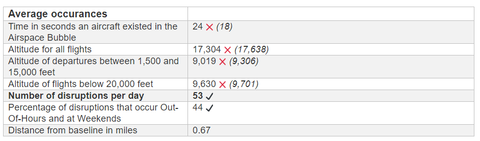
Time in seconds an aircraft existed in the Airspace Bubble
The average time in seconds it takes for a flight to travel through your airspace bubble which as a radius of 1 mile. The longer the period the greater will be the level of disruption.
Altitude for all flights
The average altitude for all flights passing through the area.
Altitude of departures between 1,500 and 15,000 feet
The average altitude forDepartingflights that are between 1,500 and 15,000 feet.
Altitude of flights below 20,000 feet
The average altitude for all flights passing through the area that are below 20,000 feet.
Percentage of disruptions that occur Out-Of-Hours and at Weekends
The percentage of disruptions that occur at weekends and/or after hours.
Distance from baseline in miles
The average distance the disruptive flight was from the baseline co-ordinates, in fractions of a mile
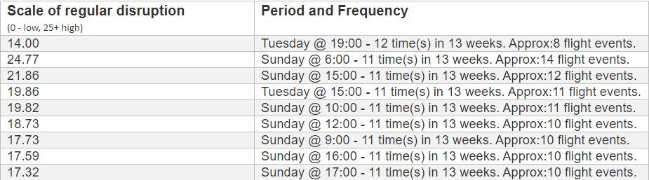
Scale of regular disruption
Prior to making your final decision we recommend you validate our Assessment by an actual site visit. The scorecard includes a list of 10 dates and times when the disruptions are most likely to occur.
Period and Frequency.
E.g. Sunday @ 6:00 – 11 time(s) in 13 weeks. Approx:14 flight events.
This example states that on Sunday mornings between 6:00am – 6:59am there is regularly* 14 flights over the postcode area.
* 11 occurrences within the 13 week or 4 week Assessment period.
Our standard model for the Assessment Index is a weighted lag indicator that represents the expected level of disruption caused by aircraft traffic at a specified location. The higher the index value for a location the higher will be the expected level of disruption caused by the aircraft, both visually and by noise output.
However, if the number of the disturbance flight events is less than 2 within a single hour then those 2 events are considered as one-off and not included within the Index.
Refinements to our standard model are possible, please see our customised survey offering.
The scale of disruption is categorised by eight bands as shown in the table below.
Value
Description
None
There are no detectable regular disruptions.
Minimal
Minimal regular aircraft disruptions i.e. not frequent or regular. The Index range is between 0.1 and 3.9.
Occasional
The are Occasional but irregular aircraft disruptions. It is highly likely the location is on a flight route. The Index range is between 4 and 6.9
Regular
Regular aircraft disruptions i.e. tends to be regular and will be noticeable at defined times of the day. It is highly likely the location is on a flight route or even on a secondary flight corridor. The Index range is between 7 and 11.9.
Frequent
Frequent aircraft disruptions i.e. tends to be regular and will be noticeable multiple times of the day. It is highly likely the location is on a flight corridor or in a flight holding stack. The Index range is between 12 and 15.9.
High
High volumes of aircraft disruptions i.e. tends to be very regular and will be noticeable at anytime of the day. It is highly likely the flights are low and the location is on multiple flight paths, or primary flight corridors or a holding stack. The Index range is between 16 and 19.9.
Very High
Very High volumes of aircraft disruptions i.e. tends to be very regular and will be noticeable at anytime of the day. It is highly likely the flights are low and the location is on a departure and arrivals flight path. The Index range is between 20 and 25.9.
Extremely High
Extremely High volumes of aircraft disruptions i.e. tends to be very regular and will be noticeable at anytime of the day. It is highly likely the flights are low and the location is on a flight path or primary flight corridor. The Index range is 26 upwards.
NOTES:
Aircraft disturbance is subjective and its effect can be impacted by other background sounds such as road noise.
Your life-style. I.e. those working from home or retired tend to be more sensitive to aircraft disturbances that occur throughout the day.
Aircraft flights frequently occur at weekends, on Bank Holidays and also between 6.00 pm and 7.00 am Monday to Friday. This makes it easy to under estimate the scale of aircraft disturbances as at these times it’s difficult to survey manually.
Each of us live inside our own personal Airspace bubble but how do we know what’s going on in that bubble and whether or not that activity could disturb the quality of our lives?
In the context of this article an Airspace bubble is a 1 mile radius from a specified point such as our home, holiday location or outdoor leisure space.
This article focuses on the impact and assessment of commercial Aircraft within our personal Airspace bubbles. Firstly, we need to understand the terms such as impact and assessment before interpreting any results. Our Assessment ignores all aircraft above 26,000 feet as above this height the noise, and possible pollution, is less likely to disturb our lives. Likewise, we also ignore aircraft that share our bubble for less that 7.5 seconds as it implies any noise would not be around long enough to create a significant disturbance.
Experience has told us that real disruption is not caused by individual aircraft operating within our Airspace bubble but it’s actually the repetitive nature of multiple aircraft at regular times that has the biggest impact.
To summarise our assessment of disturbance is based on all flights that regularly share our Airspace at the same time for periods greater than 7.5 seconds and are below 26,000 feet. Therefore, our assessment could say for a location; “between 8pm and 11pm on a Friday, Saturday and Sunday there is an 80% chance you willhear and/or see aircraft within a 10-15 minute period. The disturbance classification for this location, across all time periods, is: Frequent“.
Having an understanding of the facts you can now make a personally decision about whether this situation meets your life style criteria.
We all have the right to know and to make informed decisions.
Part of the process of buying a new home is for the buyer’s solicitor to perform a Local Authority search. But why? The conveyancing solicitors will say it’s to inform and protect the Homebuyers from any material surprises such as; flood plains, gases, landfill, historic land usage and permissions, planning issues, and detrimental long term town plans.
However, what the current Local Search does not include is any reference to the existence of Aircraft corridors, flight paths and known flight holding stacks within the area. Why?
One of the reasons “why” is because Local Authorities and District Councils believe they are powerless as they don’t own or manage the flight paths and corridors. Your local MP will also echo this sentiment too. So who is responsible and is the required information available?
The answer may surprise you as it’s not the airports themselves but a government agency known as NATs. NATs is responsible for the movement and positioning of aircraft whilst in UK airspace.
Experience tells us that the flight corridors and paths, created and managed by NATs, are very difficult and costly to change once established. So if you find yourself in a situation where you are being disrupted by aircraft it will be almost impossible to change and you will get little sympathy from the Government agencies . Meaning, it’s best to find out about the existence and usage of flight corridors and paths prior to purchasing a property. I.e. be informed! But how?
Unfortunately the “how” is not at all straight forward as although the flight information is available to the Government bodies there are no policies, guidance or standards about how the flight information should be presented to the payers of Stamp Duty.
Our objective is to lobby the UK Government departments to they can make the required changes to the Homebuyers Local Authority Searches to document the existence of local aircraft movements and flight corridors and paths. We believe the public have the right to know.
If you are interested in joining us on this journey then please leave your comments on the contact form below.
Finding out what’s going on in the sky above your house or flat in the UK is almost impossible as there is no usable public information about aircraft flights and subsequent potential disruption.
Solicitors, Estate Agents and Home Buyer surveyors won’t know either. Aircraft flights are not in scope of Local Authority and even the airports and government authorities such as NATS, if asked, will provide a very blended superficial summary for the entire area that will not be specific to your plot. We think this is wrong as we deserve to know, hence the need to escalate with our MPs.
Software Apps such as flight trackers will not provide the required information that’s specific to your plot.
Thanks to the new Aircraft Traffic Assessment service it’s now possible to avoid that sinking feeling when you realise you have just purchased a new home that is subject to frequent or low level over flights caused by arrivals, departures and flight holding stacks.
However, the the noise and visual impact of aircraft can be very subtle and it’s easy and unfair to dismiss an entire area. Just 0.5 mile in one direction or another can make a huge difference to the scale and type of disruption.
Articles, and associated comments provide additional insight about the aircraft sector and why noise and environmental issues are historically lightly regulated.
Simply select the relevant Article from the sub-menu option under “Articles ” .