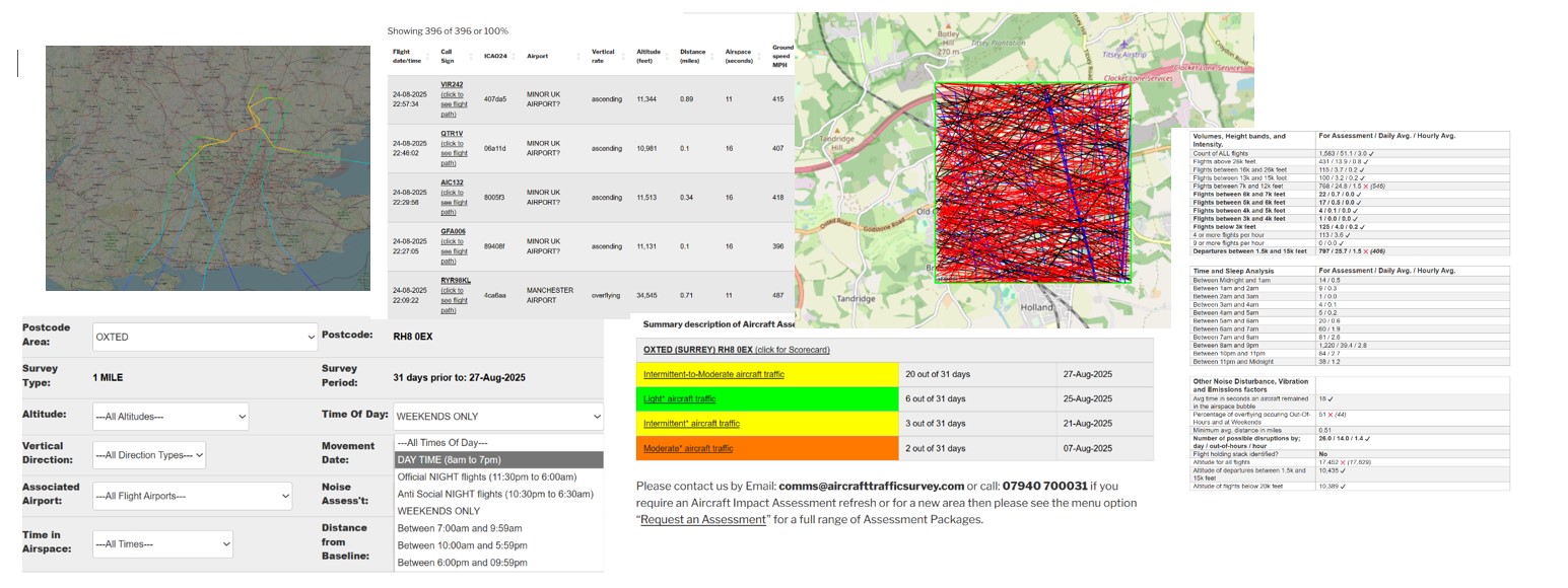
Aircraft Traffic Assessment: 31 Day Scorecard
The
✔
symbol indicates the measure is better
than the average when compared with other assessed
UK postcodes. The ❌ represents the opposite. Assessed averages are shown in brackets.
See: for a full explanation about the Assessment scorecard.
|
Assessment Scorecard headlines |
All Assessments are based on an ambient background noise of between 30 and 40 dBs i.e. a quiet residential area. Typically the noise from an overflying aircraft is between 50-65 dBs. If your property is located near to a busy road i.e. 70-75 dBs, the noise impact from aircraft will be significantly reduced, whilst the road remains busy.
|
|
Date of survey |
|
|
UK Postcode Area |
, , |
|
Baseline geo-coordinates |
, |
|
Survey type |
31 days prior to: |
|
Assessment band |
|
|
Assessment actual value |
|
|
Assessment description |
|
|
Band range |
|
|
Volumes, Height bands, and Intensity. |
For Assessment / Daily Avg. / Hourly Avg. |
|
Count of ALL flights |
0 ✔ |
|
Flights above 26k feet. |
0 ✔ |
|
Flights between 16k and 26k feet |
0 ✔ |
|
Flights between 13k and 15k feet |
0 ✔ |
|
Flights between 7k and 12k feet |
0 ✔ |
|
Flights between 6k and 7k feet |
0 ✔ |
|
Flights between 5k and 6k feet |
0 ✔ |
|
Flights between 4k and 5k feet |
0 ✔ |
|
Flights between 3k and 4k feet |
0 ✔ |
|
Flights below 3k feet |
0 ✔ |
|
4 or more flights per hour |
0 ✔ |
|
9 or more flights per hour |
0 ✔ |
|
Departures between 1.5k and 15k feet |
0 ✔ |
|
Time and Sleep Analysis |
For Assessment / Daily Avg. / Hourly Avg. |
|
Between Midnight and 1am |
|
|
Between 1am and 2am |
|
|
Between 2am and 3am |
|
|
Between 3am and 4am |
|
|
Between 4am and 5am |
|
|
Between 5am and 6am |
|
|
Between 6am and 7am |
|
|
Between 7am and 8am |
|
|
Between 8am and 9pm |
|
|
Between 10pm and 11pm |
|
|
Between 11pm and Midnight |
|
|
Other Noise Disturbance, Vibration and Emissions factors |
|
|
Avg time in seconds an aircraft remained in the airspace bubble |
✔ |
|
Percentage of overflying occuring Out-Of-Hours and at Weekends |
0 ✔ |
|
Minimum avg. distance in miles |
|
|
Number of possible disruptions by; day / out-of-hours / hour |
0 ✔ |
|
Flight holding stack identified? |
No |
|
Altitude for all flights |
❌ (0) |
|
Altitude of departures between 1.5k and 15k feet |
0 |
|
Altitude of flights below 20k feet |
❌ (0) |
|
Busiest times of day |
Day of week, time, frequency and number of flight events. |
|
|
|
|
|
|
|
|
|
|
|
|
|
|
|
|
|
|
|
|
|
|
|
|
|
|
|
Our scorecard is designed to provide a greater understanding how the assessment was reached for your selected UK post code. To enable you to validate our assessment we also provide up to 10 occurrences when we believe the disruption will be at its highest.
For those that would like to perform their own analysis we can also provide the low level flight data that includes the length of time a plane existed inside your select airspace bubble.
Evidence by associated Airport – indicative only:
| UK Airport | Count of Flights | Percentage of Total |
|---|