Click to view the on-line Tutorial
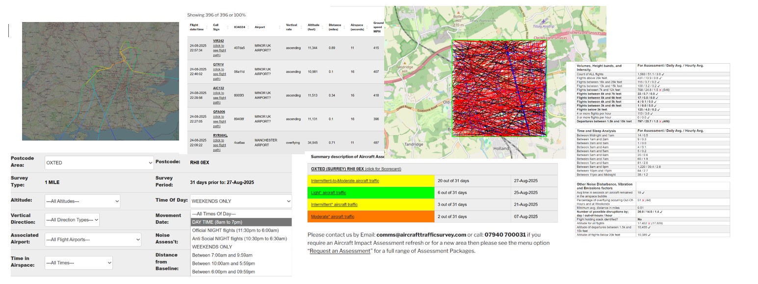
31 Day Aircraft Movements – Interactive Analysis
| Flight date sort | Flight date/time | Call Sign | ICAO24 | Airport | Vertical Rate / Compass Direction | Altitude (feet) | Distance (miles) | Airspace (seconds) | Ground speed MPH | xminLatitude | xmaxLatitude | xminlongitude | xmaxlongitude | xCall Sign |
|---|---|---|---|---|---|---|---|---|---|---|---|---|---|---|
| 20251023 | 23-10-2025 05:36:37 | BEL52B (click to see flight path) | 44ccc7 | TRANSATLANTIC FLIGHT? | overflying ==>East<== | 39000 | 0.78 | 10 | 584 | 50.9923 | 50.9947 | -1.99565 | -1.95905 | BEL52B |
| 20251016 | 16-10-2025 03:59:16 | N85M (click to see flight path) | aba612 | LONDON BIGGIN HILL AIRPORT | overflying ==>East<== | 45000 | 0.37 | 12 | 591 | 51.0041 | 50.9939 | -1.99905 | -1.95541 | N85M |
| 20251012 | 12-10-2025 02:55:42 | EXS87MD (click to see flight path) | 406a62 | EAST MIDLANDS AIRPORT | overflying ==>North-East<== | 37983 | 0.65 | 13 | 475 | 50.9961 | 51.0185 | -1.99989 | -1.98481 | EXS87MD |
| 20251011 | 11-10-2025 01:26:16 | CHG552 (click to see flight path) | 440251 | TRANSATLANTIC FLIGHT? | overflying ==>East<== | 39000 | 0.08 | 12 | 549 | 51.0046 | 51.0071 | -1.99623 | -1.95571 | CHG552 |
| 20250927 | 27-09-2025 05:15:42 | CHH730 (click to see flight path) | 780707 | TRANSATLANTIC FLIGHT? | overflying ==>East<== | 35981 | 0.7 | 11 | 618 | 51.0137 | 51.0162 | -1.99776 | -1.95586 | CHH730 |
| 20250924 | 24-09-2025 05:58:07 | DJT101 (click to see flight path) | 398699 | TRANSATLANTIC FLIGHT? | overflying ==>South-East<== | 37050 | 0.11 | 16 | 530 | 51.0136 | 50.9926 | -1.99974 | -1.9561 | DJT101 |