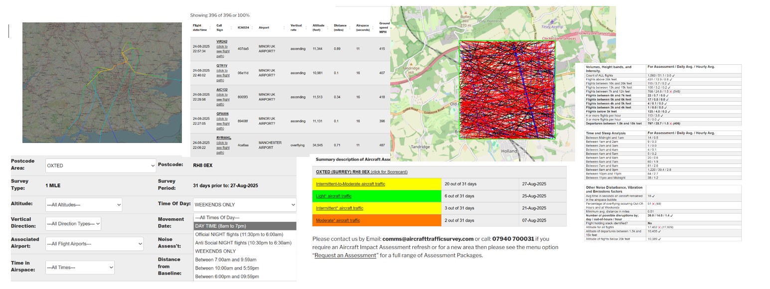
Click to view the on-line Tutorial
31 Day Aircraft Movements – Interactive Analysis
| Flight date sort | Flight date/time | Call Sign | ICAO24 | Airport | Vertical Rate / Compass Direction | Altitude (feet) | Distance (miles) | Airspace (seconds) | Ground speed MPH | xminLatitude | xmaxLatitude | xminlongitude | xmaxlongitude | xCall Sign |
|---|---|---|---|---|---|---|---|---|---|---|---|---|---|---|
| 20250831 | 31-08-2025 23:34:47 | EZY58YD (click to see flight path) | 4078f0 | BRISTOL AIRPORT | descending ==>North-West<== | 31428 | 2.75 | 18 | 573 | 51.0934 | 51.1171 | -0.164646 | -0.218093 | EZY58YD |
| 20250831 | 31-08-2025 05:50:57 | UBT70Z (click to see flight path) | 40742e | LONDON GATWICK AIRPORT | descending ==>North-East<== | 7703 | 1.49 | 49 | 320 | 51.0308 | 51.0661 | -0.239101 | -0.163978 | UBT70Z |
| 20250831 | 31-08-2025 05:49:51 | HLE60 (click to see flight path) | 4074bf | LONDON GATWICK AIRPORT | overflying ==>South<== | 1646 | 2.88 | 81 | 150 | 51.1169 | 51.0683 | -0.171624 | -0.162271 | HLE60 |
| 20250831 | 31-08-2025 05:45:56 | UAL994 (click to see flight path) | a05627 | TRANSATLANTIC FLIGHT? | overflying ==>East<== | 36998 | 0.71 | 33 | 640 | 51.0572 | 51.0695 | -0.295868 | -0.162568 | UAL994 |
| 20250831 | 31-08-2025 05:13:25 | ACA886 (click to see flight path) | c04fd7 | TRANSATLANTIC FLIGHT? | overflying ==>East<== | 37000 | 1.74 | 34 | 613 | 51.0434 | 51.0536 | -0.293587 | -0.163459 | ACA886 |
| 20250831 | 31-08-2025 04:51:00 | DAL130 (click to see flight path) | ab8862 | TRANSATLANTIC FLIGHT? | overflying ==>East<== | 34000 | 0.36 | 34 | 602 | 51.0776 | 51.0799 | -0.296783 | -0.16628 | DAL130 |
| 20250831 | 31-08-2025 03:01:46 | DLH417 (click to see flight path) | 3c64fa | TRANSATLANTIC FLIGHT? | ascending ==>North<== | 39000 | 2.41 | 21 | 552 | 51.0937 | 51.0937 | -0.184708 | -0.184708 | DLH417 |
| 20250831 | 31-08-2025 01:01:38 | RYR3SV (click to see flight path) | 4cac1f | BRISTOL AIRPORT | descending ==>North-West<== | 34445 | 1.16 | 43 | 525 | 51.0629 | 51.117 | -0.162568 | -0.277634 | RYR3SV |
| 20250830 | 30-08-2025 05:30:52 | UAL950 (click to see flight path) | a21633 | TRANSATLANTIC FLIGHT? | overflying ==>East<== | 36000 | 1.66 | 34 | 604 | 51.0429 | 51.0556 | -0.296249 | -0.167096 | UAL950 |
| 20250830 | 30-08-2025 05:18:00 | CHH730 (click to see flight path) | 78158f | TRANSATLANTIC FLIGHT? | descending ==>East<== | 36004 | 1.14 | 34 | 607 | 51.051 | 51.0632 | -0.293736 | -0.164337 | CHH730 |
| 20250830 | 30-08-2025 04:38:29 | EDW1301 (click to see flight path) | 4b1900 | TRANSATLANTIC FLIGHT? | overflying ==>South-East<== | 39000 | 1.74 | 29 | 608 | 51.0874 | 51.0312 | -0.296185 | -0.227298 | EDW1301 |
| 20250830 | 30-08-2025 03:50:46 | ACA840 (click to see flight path) | c04fbb | TRANSATLANTIC FLIGHT? | overflying ==>East<== | 37002 | 1.29 | 36 | 579 | 51.0907 | 51.0942 | -0.297318 | -0.163904 | ACA840 |
| 20250830 | 30-08-2025 01:33:51 | EZY51NY (click to see flight path) | 400e5a | LONDON GATWICK AIRPORT | descending ==>East<== | 10185 | 0.62 | 61 | 363 | 51.0803 | 51.0545 | -0.29767 | -0.163651 | EZY51NY |
| 20250830 | 30-08-2025 01:05:29 | EIN4VM (click to see flight path) | 4ca935 | TRANSATLANTIC FLIGHT? | overflying ==>North-West<== | 35995 | 1.34 | 53 | 417 | 51.0712 | 51.1169 | -0.163345 | -0.284805 | EIN4VM |
| 20250830 | 30-08-2025 00:33:48 | EZY82HC (click to see flight path) | 407f64 | LONDON GATWICK AIRPORT | descending ==>South-East<== | 10388 | 2.23 | 41 | 378 | 51.0604 | 51.0306 | -0.297447 | -0.211029 | EZY82HC |
| 20250830 | 30-08-2025 00:27:38 | WUK3714 (click to see flight path) | 40804e | LONDON GATWICK AIRPORT | overflying ==>South-East<== | 3305 | 0.86 | 98 | 271 | 51.1156 | 51.0541 | -0.260925 | -0.163607 | WUK3714 |
| 20250829 | 29-08-2025 23:51:45 | EZY54HP (click to see flight path) | 406016 | BRISTOL AIRPORT | overflying ==>North-West<== | 36005 | 0.86 | 56 | 435 | 51.0576 | 51.1162 | -0.163956 | -0.28656 | EZY54HP |
| 20250829 | 29-08-2025 23:45:38 | RYR70YD (click to see flight path) | 4d2232 | TRANSATLANTIC FLIGHT? | overflying ==>North-West<== | 38000 | 1.17 | 52 | 453 | 51.0681 | 51.1167 | -0.163116 | -0.292103 | RYR70YD |
| 20250829 | 29-08-2025 05:59:59 | EZY54PB (click to see flight path) | 40666c | LONDON GATWICK AIRPORT | ascending ==>South-East<== | 5004 | 0.07 | 81 | 263 | 51.1163 | 51.0417 | -0.260851 | -0.195923 | EZY54PB |
| 20250829 | 29-08-2025 05:56:34 | EZY17BU (click to see flight path) | 4080f7 | LONDON GATWICK AIRPORT | ascending ==>South-East<== | 5626 | 1.33 | 80 | 287 | 51.1072 | 51.0311 | -0.297699 | -0.220617 | EZY17BU |
| 20250829 | 29-08-2025 05:54:08 | EZY32DG (click to see flight path) | 407f66 | LONDON GATWICK AIRPORT | ascending ==>South-East<== | 5515 | 2.72 | 41 | 274 | 51.0658 | 51.0305 | -0.297373 | -0.25116 | EZY32DG |
| 20250829 | 29-08-2025 05:50:55 | DLH463 (click to see flight path) | 3c4b32 | TRANSATLANTIC FLIGHT? | overflying ==>East<== | 37000 | 1.28 | 35 | 603 | 51.0913 | 51.0931 | -0.296482 | -0.163574 | DLH463 |
| 20250829 | 29-08-2025 05:42:28 | CMB514 (click to see flight path) | ac01ae | TRANSATLANTIC FLIGHT? | overflying ==>West<== | 38000 | 1.41 | 41 | 518 | 51.0587 | 51.0476 | -0.163385 | -0.297241 | CMB514 |
| 20250829 | 29-08-2025 04:59:38 | AAL704 (click to see flight path) | aa305f | TRANSATLANTIC FLIGHT? | overflying ==>East<== | 37000 | 0.75 | 35 | 593 | 51.0834 | 51.0855 | -0.296173 | -0.165939 | AAL704 |
| 20250829 | 29-08-2025 03:48:11 | FPO7SN (click to see flight path) | 39a204 | TRANSATLANTIC FLIGHT? | overflying ==>North-West<== | 38000 | 1.5 | 40 | 509 | 51.0306 | 51.073 | -0.184615 | -0.294189 | FPO7SN |
| 20250829 | 29-08-2025 01:33:37 | TOM695 (click to see flight path) | 40665e | TRANSATLANTIC FLIGHT? | overflying ==>North-West<== | 36000 | 0.98 | 46 | 506 | 51.037 | 51.0789 | -0.163879 | -0.297546 | TOM695 |
| 20250829 | 29-08-2025 00:41:04 | GTI8042 (click to see flight path) | a86d51 | TRANSATLANTIC FLIGHT? | overflying ==>East<== | 41005 | 2.09 | 36 | 558 | 51.1033 | 51.1045 | -0.292474 | -0.165482 | GTI8042 |
| 20250829 | 29-08-2025 00:02:46 | TOM11T (click to see flight path) | 4075f3 | LONDON GATWICK AIRPORT | overflying ==>North-East<== | 9992 | 2.72 | 27 | 327 | 51.0307 | 51.0552 | -0.202134 | -0.162939 | TOM11T |
| 20250828 | 28-08-2025 23:57:40 | EZY71GN (click to see flight path) | 40768d | LONDON GATWICK AIRPORT | descending ==>North-East<== | 7835 | 1.11 | 57 | 316 | 51.0309 | 51.0716 | -0.250607 | -0.163574 | EZY71GN |
| 20250828 | 28-08-2025 23:46:53 | EZY82BX (click to see flight path) | 407f5f | GLASGOW INTERNATIONAL AIRPORT | overflying ==>South<== | 3368 | 1.63 | 92 | 236 | 51.1158 | 51.0305 | -0.200129 | -0.177841 | EZY82BX |
| 20250828 | 28-08-2025 23:33:59 | EIN465 (click to see flight path) | 4ca5c8 | TRANSATLANTIC FLIGHT? | overflying ==>North-West<== | 36003 | 2.03 | 32 | 512 | 51.0828 | 51.1164 | -0.163651 | -0.252991 | EIN465 |
| 20250828 | 28-08-2025 05:52:24 | TRA26M (click to see flight path) | 4854cf | TRANSATLANTIC FLIGHT? | overflying ==>South-West<== | 36000 | 1.34 | 42 | 494 | 51.0821 | 51.0305 | -0.163269 | -0.267105 | TRA26M |
| 20250828 | 28-08-2025 05:47:24 | DLH441 (click to see flight path) | 3c4b35 | TRANSATLANTIC FLIGHT? | overflying ==>East<== | 37000 | 2.39 | 35 | 596 | 51.1077 | 51.1088 | -0.295443 | -0.16331 | DLH441 |
| 20250828 | 28-08-2025 05:37:12 | UAL108 (click to see flight path) | a2ca5d | TRANSATLANTIC FLIGHT? | overflying ==>East<== | 39995 | 2.28 | 34 | 608 | 51.1061 | 51.1072 | -0.296173 | -0.165253 | UAL108 |
| 20250828 | 28-08-2025 03:30:07 | CFG2017 (click to see flight path) | 3c7a41 | TRANSATLANTIC FLIGHT? | overflying ==>East<== | 39000 | 2.49 | 36 | 583 | 51.1085 | 51.111 | -0.297241 | -0.165024 | CFG2017 |
| 20250828 | 28-08-2025 02:06:20 | TOM9MG (click to see flight path) | 40753d | BRISTOL AIRPORT | descending ==>North-West<== | 32305 | 1.04 | 46 | 518 | 51.0327 | 51.0748 | -0.162659 | -0.296334 | TOM9MG |
| 20250828 | 28-08-2025 02:04:50 | EZY21VB (click to see flight path) | 4074b8 | LONDON LUTON AIRPORT | descending ==>North<== | 17034 | 2.38 | 52 | 415 | 51.0309 | 51.1165 | -0.296037 | -0.274732 | EZY21VB |
| 20250828 | 28-08-2025 01:48:40 | EZY29FB (click to see flight path) | 405b65 | LONDON LUTON AIRPORT | descending ==>North<== | 17978 | 2.57 | 43 | 463 | 51.0379 | 51.1171 | -0.297744 | -0.283121 | EZY29FB |
| 20250828 | 28-08-2025 01:35:41 | TOM561 (click to see flight path) | 4067f2 | TRANSATLANTIC FLIGHT? | descending ==>North-West<== | 37839 | 0.32 | 49 | 536 | 51.0348 | 51.1009 | -0.163803 | -0.295295 | TOM561 |
| 20250828 | 28-08-2025 01:27:14 | EZY47XZ (click to see flight path) | 4075df | BRISTOL AIRPORT | descending ==>North-West<== | 32015 | 1.03 | 46 | 491 | 51.0314 | 51.0881 | -0.185357 | -0.295592 | EZY47XZ |
| 20250828 | 28-08-2025 01:00:19 | EIN4VM (click to see flight path) | 4ca292 | TRANSATLANTIC FLIGHT? | overflying ==>North-West<== | 38014 | 1.78 | 18 | 525 | 51.0477 | 51.0699 | -0.240883 | -0.297394 | EIN4VM |
| 20250828 | 28-08-2025 00:59:59 | EIN4VM (click to see flight path) | 4ca292 | TRANSATLANTIC FLIGHT? | overflying ==>North-West<== | 37985 | 1.86 | 15 | 525 | 51.0311 | 51.0477 | -0.198348 | -0.240883 | EIN4VM |
| 20250828 | 28-08-2025 00:58:18 | EXS7HX (click to see flight path) | 4078fe | BRISTOL AIRPORT | overflying ==>North-West<== | 37000 | 1.4 | 39 | 524 | 51.068 | 51.1168 | -0.163978 | -0.268497 | EXS7HX |
| 20250828 | 28-08-2025 00:56:25 | EZY57VH (click to see flight path) | 408183 | BRISTOL AIRPORT | descending ==>North-West<== | 36295 | 2.81 | 18 | 539 | 51.0313 | 51.0564 | -0.251007 | -0.296557 | EZY57VH |
| 20250828 | 28-08-2025 00:25:11 | TOM8VC (click to see flight path) | 405e24 | BRISTOL AIRPORT | overflying ==>North-West<== | 35000 | 1.6 | 35 | 521 | 51.0722 | 51.1158 | -0.164795 | -0.258401 | TOM8VC |
| 20250828 | 28-08-2025 00:11:28 | EZY71MJ (click to see flight path) | 407a05 | BRISTOL AIRPORT | descending ==>North-West<== | 34130 | 1.95 | 31 | 528 | 51.0779 | 51.1164 | -0.162659 | -0.247118 | EZY71MJ |
| 20250827 | 27-08-2025 05:27:26 | TRA74R (click to see flight path) | 4866ee | TRANSATLANTIC FLIGHT? | overflying ==>South-West<== | 38000 | 1.16 | 49 | 452 | 51.1169 | 51.0604 | -0.188549 | -0.297744 | TRA74R |
| 20250827 | 27-08-2025 03:54:04 | AFR279 (click to see flight path) | 394a15 | TRANSATLANTIC FLIGHT? | overflying ==>South-East<== | 35000 | 2.57 | 22 | 533 | 51.116 | 51.0755 | -0.2005 | -0.163422 | AFR279 |
| 20250827 | 27-08-2025 03:50:45 | FPO7SN (click to see flight path) | 39a205 | TRANSATLANTIC FLIGHT? | overflying ==>North-West<== | 36000 | 2.86 | 20 | 494 | 51.0305 | 51.0513 | -0.244293 | -0.29686 | FPO7SN |
| 20250827 | 27-08-2025 02:49:26 | CHG572 (click to see flight path) | 448465 | TRANSATLANTIC FLIGHT? | overflying ==>East<== | 35000 | 2.39 | 34 | 622 | 51.1055 | 51.1109 | -0.297002 | -0.163498 | CHG572 |
| 20250827 | 27-08-2025 02:41:14 | EXS74LT (click to see flight path) | 40717a | LONDON STANSTED AIRPORT | descending ==>North-East<== | 20569 | 1.52 | 42 | 514 | 51.0321 | 51.1086 | -0.224686 | -0.16243 | EXS74LT |
| 20250827 | 27-08-2025 01:21:52 | EZY48CF (click to see flight path) | 4080ad | BRISTOL AIRPORT | descending ==>West<== | 31606 | 0.12 | 49 | 460 | 51.0547 | 51.089 | -0.162865 | -0.297012 | EZY48CF |
| 20250827 | 27-08-2025 00:58:23 | HLE60 (click to see flight path) | 40709d | LONDON GATWICK AIRPORT | overflying ==>North<== | 1750 | 2.92 | 69 | 156 | 51.0303 | 51.0724 | -0.17334 | -0.16243 | HLE60 |
| 20250826 | 26-08-2025 05:49:27 | TRA85L (click to see flight path) | 484b2a | TRANSATLANTIC FLIGHT? | overflying ==>South-West<== | 37000 | 0.83 | 55 | 446 | 51.0921 | 51.0308 | -0.162735 | -0.284902 | TRA85L |
| 20250826 | 26-08-2025 05:12:24 | UAL618 (click to see flight path) | a754b5 | TRANSATLANTIC FLIGHT? | descending ==>East<== | 36378 | 0.69 | 36 | 587 | 51.0871 | 51.0804 | -0.297373 | -0.162506 | UAL618 |
| 20250826 | 26-08-2025 04:39:59 | CMB585 (click to see flight path) | a9c52e | TRANSATLANTIC FLIGHT? | overflying ==>East<== | 38000 | 2.43 | 33 | 634 | 51.1076 | 51.1102 | -0.296854 | -0.163533 | CMB585 |
| 20250826 | 26-08-2025 04:22:15 | UAL944 (click to see flight path) | a0a545 | TRANSATLANTIC FLIGHT? | overflying ==>East<== | 36987 | 1.72 | 32 | 645 | 51.0434 | 51.0537 | -0.295963 | -0.166016 | UAL944 |
| 20250826 | 26-08-2025 01:56:48 | EZY78FH (click to see flight path) | 407fff | LONDON GATWICK AIRPORT | overflying ==>West<== | 8000 | 2.99 | 62 | 273 | 51.0308 | 51.0303 | -0.162888 | -0.270615 | EZY78FH |
| 20250826 | 26-08-2025 00:58:20 | UAE6MR (click to see flight path) | 8963a3 | TRANSATLANTIC FLIGHT? | overflying ==>East<== | 35000 | 1.27 | 34 | 618 | 51.0913 | 51.093 | -0.294342 | -0.162582 | UAE6MR |
| 20250826 | 26-08-2025 00:11:53 | RYR54DU (click to see flight path) | 4cae66 | MANCHESTER AIRPORT | descending ==>South-West<== | 5873 | 1.22 | 104 | 163 | 51.1171 | 51.0852 | -0.202208 | -0.297546 | RYR54DU |
| 20250826 | 26-08-2025 00:01:07 | EZY17EJ (click to see flight path) | 407e61 | LONDON GATWICK AIRPORT | overflying ==>West<== | 8000 | 2.72 | 76 | 276 | 51.035 | 51.032 | -0.164053 | -0.297596 | EZY17EJ |
| 20250825 | 25-08-2025 23:48:22 | EIN449 (click to see flight path) | 4ca2c9 | TRANSATLANTIC FLIGHT? | overflying ==>West<== | 36010 | 1.71 | 46 | 473 | 51.0364 | 51.0601 | -0.164185 | -0.297699 | EIN449 |
| 20250825 | 25-08-2025 23:37:29 | RYR73SE (click to see flight path) | 4cae9b | TRANSATLANTIC FLIGHT? | overflying ==>North-West<== | 38000 | 1.77 | 39 | 478 | 51.0786 | 51.1166 | -0.163607 | -0.265274 | RYR73SE |
| 20250825 | 25-08-2025 05:34:22 | UAL950 (click to see flight path) | a1c82a | TRANSATLANTIC FLIGHT? | overflying ==>East<== | 35000 | 0.8 | 35 | 582 | 51.056 | 51.0679 | -0.294724 | -0.165482 | UAL950 |
| 20250825 | 25-08-2025 01:59:08 | EXS9KF (click to see flight path) | 407f8c | BRISTOL AIRPORT | descending ==>North-West<== | 34858 | 0.94 | 49 | 483 | 51.0598 | 51.1169 | -0.164871 | -0.284902 | EXS9KF |
| 20250825 | 25-08-2025 01:31:42 | TOM325 (click to see flight path) | 407c0a | BRISTOL AIRPORT | overflying ==>North-West<== | 36000 | 2.5 | 25 | 527 | 51.0879 | 51.1163 | -0.162354 | -0.22583 | TOM325 |
| 20250825 | 25-08-2025 01:00:49 | RYR168Z (click to see flight path) | 4cae57 | TRANSATLANTIC FLIGHT? | overflying ==>North-West<== | 36000 | 2.59 | 23 | 509 | 51.0306 | 51.0556 | -0.232272 | -0.296402 | RYR168Z |
| 20250825 | 25-08-2025 00:57:22 | RYR7237 (click to see flight path) | 4d234b | TRANSATLANTIC FLIGHT? | overflying ==>North-West<== | 36000 | 0.35 | 47 | 512 | 51.0431 | 51.0931 | -0.165558 | -0.296326 | RYR7237 |
| 20250825 | 25-08-2025 00:26:07 | TOM1GT (click to see flight path) | 408086 | BRISTOL AIRPORT | descending ==>North-West<== | 33274 | 1.39 | 43 | 529 | 51.0338 | 51.0696 | -0.163459 | -0.296557 | TOM1GT |
| 20250824 | 24-08-2025 23:41:51 | TOM87X (click to see flight path) | 4080cf | LONDON GATWICK AIRPORT | overflying ==>West<== | 7000 | 2.67 | 67 | 312 | 51.0388 | 51.0312 | -0.163803 | -0.296037 | TOM87X |
| 20250824 | 24-08-2025 23:39:29 | EXS71U (click to see flight path) | 407f7d | BRISTOL AIRPORT | descending ==>North-West<== | 32031 | 2.81 | 21 | 459 | 51.0944 | 51.1169 | -0.164337 | -0.215302 | EXS71U |
| 20250824 | 24-08-2025 04:25:10 | ICE48P (click to see flight path) | 4cc573 | TRANSATLANTIC FLIGHT? | descending ==>South-East<== | 36727 | 0.67 | 45 | 572 | 51.1118 | 51.0309 | -0.297744 | -0.195675 | ICE48P |
| 20250824 | 24-08-2025 02:47:24 | EZY54YP (click to see flight path) | 4071d7 | LONDON GATWICK AIRPORT | descending ==>West<== | 6306 | 2.75 | 73 | 281 | 51.0303 | 51.0382 | -0.166321 | -0.297076 | EZY54YP |
| 20250824 | 24-08-2025 01:27:47 | EZY13GL (click to see flight path) | 40815b | LONDON GATWICK AIRPORT | descending ==>West<== | 6309 | 2.65 | 73 | 289 | 51.0335 | 51.0377 | -0.163269 | -0.29747 | EZY13GL |
| 20250824 | 24-08-2025 00:26:16 | EZY57VH (click to see flight path) | 407569 | BRISTOL AIRPORT | descending ==>North-West<== | 30319 | 0.9 | 58 | 415 | 51.0579 | 51.1157 | -0.162888 | -0.283863 | EZY57VH |
| 20250824 | 24-08-2025 00:23:38 | EZY68TW (click to see flight path) | 406c72 | BRISTOL AIRPORT | descending ==>North-West<== | 32806 | 0.18 | 58 | 465 | 51.0372 | 51.1041 | -0.163236 | -0.297744 | EZY68TW |
| 20250824 | 24-08-2025 00:21:34 | RYR2546 (click to see flight path) | 4caea0 | LONDON STANSTED AIRPORT | overflying ==>North-West<== | 38000 | 1.49 | 48 | 436 | 51.0735 | 51.1166 | -0.162791 | -0.277924 | RYR2546 |
| 20250824 | 24-08-2025 00:11:57 | EZY12RN (click to see flight path) | 406b91 | BRISTOL AIRPORT | descending ==>North-West<== | 37889 | 1.5 | 43 | 442 | 51.0311 | 51.0799 | -0.20295 | -0.295486 | EZY12RN |
| 20250823 | 23-08-2025 23:56:55 | URO682 (click to see flight path) | 400f0b | BOURNEMOUTH AIRPORT | ascending ==>East<== | 23267 | 2.19 | 39 | 528 | 51.0389 | 51.0451 | -0.293961 | -0.163269 | URO682 |
| 20250823 | 23-08-2025 23:52:56 | RYR46LC (click to see flight path) | 4ca95e | TRANSATLANTIC FLIGHT? | overflying ==>North-West<== | 36000 | 1.91 | 38 | 464 | 51.0808 | 51.117 | -0.163088 | -0.259663 | RYR46LC |
| 20250823 | 23-08-2025 23:38:52 | EZY73RA (click to see flight path) | 407fc7 | LONDON GATWICK AIRPORT | descending ==>West<== | 5609 | 1.89 | 66 | 320 | 51.0503 | 51.042 | -0.162964 | -0.297546 | EZY73RA |
| 20250823 | 23-08-2025 05:27:09 | CHH730 (click to see flight path) | 78141e | TRANSATLANTIC FLIGHT? | descending ==>East<== | 38600 | 0.54 | 35 | 596 | 51.076 | 51.087 | -0.2948 | -0.164275 | CHH730 |
| 20250823 | 23-08-2025 05:05:50 | AAL44 (click to see flight path) | aa944a | TRANSATLANTIC FLIGHT? | overflying ==>South-East<== | 37000 | 2.73 | 15 | 617 | 51.0614 | 51.0331 | -0.295715 | -0.257568 | AAL44 |
| 20250823 | 23-08-2025 02:43:54 | HLE60 (click to see flight path) | 4074bf | LONDON GATWICK AIRPORT | ascending ==>South-West<== | 1430 | 2.85 | 59 | 162 | 51.1166 | 51.0871 | -0.257956 | -0.297373 | HLE60 |
| 20250823 | 23-08-2025 01:08:26 | TOM4BG (click to see flight path) | 40769a | BRISTOL AIRPORT | descending ==>North-West<== | 34361 | 1.28 | 47 | 452 | 51.0652 | 51.1163 | -0.162964 | -0.271378 | TOM4BG |
| 20250823 | 23-08-2025 01:01:35 | RYR73TJ (click to see flight path) | 4ca73e | LONDON STANSTED AIRPORT | ascending ==>South<== | 25126 | 0.94 | 38 | 561 | 51.1154 | 51.031 | -0.217425 | -0.198645 | RYR73TJ |
| 20250823 | 23-08-2025 00:14:05 | UAE7350 (click to see flight path) | 896626 | TRANSATLANTIC FLIGHT? | overflying ==>East<== | 40001 | 0.31 | 37 | 571 | 51.0716 | 51.0821 | -0.296402 | -0.163574 | UAE7350 |
| 20250822 | 22-08-2025 03:54:52 | FPO7SN (click to see flight path) | 39a204 | TRANSATLANTIC FLIGHT? | overflying ==>North-West<== | 36000 | 0.69 | 51 | 482 | 51.0362 | 51.0874 | -0.163236 | -0.296555 | FPO7SN |
| 20250822 | 22-08-2025 01:52:55 | TOM6485 (click to see flight path) | 405e24 | TRANSATLANTIC FLIGHT? | overflying ==>North-West<== | 36000 | 2.25 | 33 | 492 | 51.0901 | 51.1171 | -0.162277 | -0.256546 | TOM6485 |
| 20250822 | 22-08-2025 01:05:59 | WUK6JQ (click to see flight path) | 407b8b | LONDON GATWICK AIRPORT | descending ==>West<== | 6333 | 2.26 | 71 | 298 | 51.0472 | 51.0394 | -0.162659 | -0.296097 | WUK6JQ |
| 20250822 | 22-08-2025 01:04:21 | TOM515 (click to see flight path) | 40825d | LONDON GATWICK AIRPORT | descending ==>West<== | 6405 | 1.78 | 71 | 303 | 51.0568 | 51.0379 | -0.163978 | -0.296402 | TOM515 |
| 20250822 | 22-08-2025 00:52:28 | RYR2EL (click to see flight path) | 4cadf9 | LONDON STANSTED AIRPORT | descending ==>North<== | 22980 | 2.11 | 56 | 383 | 51.031 | 51.117 | -0.289876 | -0.26825 | RYR2EL |
| 20250821 | 21-08-2025 03:55:00 | EZY61RV (click to see flight path) | 407fc7 | LONDON GATWICK AIRPORT | descending ==>West<== | 6647 | 2.34 | 76 | 275 | 51.0405 | 51.0391 | -0.163422 | -0.296021 | EZY61RV |
| 20250821 | 21-08-2025 03:52:56 | FPO7SN (click to see flight path) | 39a204 | TRANSATLANTIC FLIGHT? | overflying ==>North-West<== | 38025 | 1.72 | 37 | 494 | 51.0309 | 51.0717 | -0.19989 | -0.296021 | FPO7SN |
| 20250821 | 21-08-2025 01:52:34 | EFW2617 (click to see flight path) | 405456 | LONDON GATWICK AIRPORT | overflying ==>West<== | 2919 | 0.94 | 85 | 266 | 51.076 | 51.0422 | -0.163574 | -0.297165 | EFW2617 |
| 20250821 | 21-08-2025 01:50:37 | RYR48SG (click to see flight path) | 4ca4ee | LONDON STANSTED AIRPORT | descending ==>North<== | 17321 | 2.58 | 44 | 400 | 51.0458 | 51.1158 | -0.297775 | -0.278854 | RYR48SG |
| 20250821 | 21-08-2025 01:09:14 | EZY57VH (click to see flight path) | 4072c7 | BRISTOL AIRPORT | descending ==>North-West<== | 35430 | 1.15 | 45 | 495 | 51.0383 | 51.0731 | -0.164869 | -0.295517 | EZY57VH |
| 20250821 | 21-08-2025 00:10:05 | EZY59VW (click to see flight path) | 4080f6 | LONDON GATWICK AIRPORT | descending ==>West<== | 7894 | 2.88 | 39 | 298 | 51.0406 | 51.0303 | -0.163681 | -0.235596 | EZY59VW |
| 20250820 | 20-08-2025 23:49:10 | EZY87YE (click to see flight path) | 407f60 | LONDON GATWICK AIRPORT | descending ==>West<== | 6608 | 1.79 | 75 | 289 | 51.0569 | 51.0377 | -0.162735 | -0.296707 | EZY87YE |
| 20250820 | 20-08-2025 05:53:22 | ETH518 (click to see flight path) | 040087 | TRANSATLANTIC FLIGHT? | overflying ==>West<== | 35988 | 1.47 | 37 | 599 | 51.0345 | 51.0676 | -0.16576 | -0.297012 | ETH518 |
| 20250820 | 20-08-2025 05:36:55 | AAL704 (click to see flight path) | aa8315 | TRANSATLANTIC FLIGHT? | overflying ==>East<== | 37000 | 1.54 | 41 | 506 | 51.0952 | 51.0968 | -0.296249 | -0.162791 | AAL704 |
| 20250820 | 20-08-2025 05:26:08 | HLE60 (click to see flight path) | 40709d | LONDON GATWICK AIRPORT | overflying ==>South-West<== | 1250 | 2.3 | 77 | 179 | 51.117 | 51.0757 | -0.239992 | -0.297699 | HLE60 |
| 20250820 | 20-08-2025 00:32:18 | EZY85AP (click to see flight path) | 40772e | LONDON GATWICK AIRPORT | descending ==>West<== | 7102 | 2.7 | 65 | 320 | 51.0387 | 51.0309 | -0.164337 | -0.29574 | EZY85AP |
| 20250820 | 20-08-2025 00:23:57 | TOM639 (click to see flight path) | 408086 | BRISTOL AIRPORT | descending ==>North-West<== | 32492 | 1.64 | 46 | 484 | 51.0303 | 51.0655 | -0.164566 | -0.295486 | TOM639 |
| 20250820 | 20-08-2025 00:02:24 | EZY68UZ (click to see flight path) | 406133 | LONDON GATWICK AIRPORT | descending ==>West<== | 6984 | 2.46 | 64 | 284 | 51.0306 | 51.0337 | -0.184838 | -0.296854 | EZY68UZ |
| 20250819 | 19-08-2025 23:40:42 | DHK528 (click to see flight path) | 407cf7 | EAST MIDLANDS AIRPORT | overflying ==>South-East<== | 39000 | 0.47 | 43 | 531 | 51.1165 | 51.0328 | -0.273132 | -0.212326 | DHK528 |
| 20250819 | 19-08-2025 03:05:41 | NBT30G (click to see flight path) | 47ae38 | TRANSATLANTIC FLIGHT? | ascending ==>North-West<== | 26962 | 1.7 | 30 | 619 | 51.0759 | 51.1167 | -0.164053 | -0.263226 | NBT30G |
| 20250819 | 19-08-2025 00:57:45 | EZY15HD (click to see flight path) | 4072c7 | BRISTOL AIRPORT | descending ==>North-West<== | 33229 | 0.48 | 47 | 515 | 51.0507 | 51.1 | -0.162506 | -0.294998 | EZY15HD |
| 20250819 | 19-08-2025 00:42:48 | WUK1PQ (click to see flight path) | 40805d | LONDON GATWICK AIRPORT | descending ==>West<== | 6739 | 2.4 | 71 | 297 | 51.0386 | 51.0394 | -0.162939 | -0.297394 | WUK1PQ |
| 20250819 | 19-08-2025 00:21:26 | EZY8576 (click to see flight path) | 406666 | LONDON GATWICK AIRPORT | descending ==>West<== | 6356 | 2.48 | 63 | 334 | 51.0445 | 51.0368 | -0.16383 | -0.296249 | EZY8576 |
| 20250818 | 18-08-2025 23:31:08 | EZY32LH (click to see flight path) | 407f64 | LONDON GATWICK AIRPORT | descending ==>West<== | 6433 | 2.91 | 72 | 295 | 51.0354 | 51.0316 | -0.162735 | -0.296705 | EZY32LH |
| 20250818 | 18-08-2025 05:55:29 | CHH730 (click to see flight path) | 78158f | TRANSATLANTIC FLIGHT? | descending ==>East<== | 32814 | 1.55 | 36 | 571 | 51.0495 | 51.0531 | -0.294478 | -0.16383 | CHH730 |
| 20250818 | 18-08-2025 05:52:53 | AFR375U (click to see flight path) | 39cf0b | TRANSATLANTIC FLIGHT? | descending ==>South-East<== | 37642 | 0.59 | 46 | 556 | 51.1165 | 51.0314 | -0.260086 | -0.168061 | AFR375U |
| 20250818 | 18-08-2025 05:50:14 | CES201 (click to see flight path) | 781103 | LONDON GATWICK AIRPORT | descending ==>West<== | 5846 | 1.18 | 51 | 312 | 51.0588 | 51.0521 | -0.196715 | -0.297447 | CES201 |
| 20250818 | 18-08-2025 04:30:17 | ICE48P (click to see flight path) | 4cc582 | TRANSATLANTIC FLIGHT? | overflying ==>South-East<== | 37000 | 0.56 | 50 | 527 | 51.116 | 51.032 | -0.266122 | -0.162354 | ICE48P |
| 20250818 | 18-08-2025 03:04:49 | EZY78QH (click to see flight path) | 407575 | BRISTOL AIRPORT | overflying ==>North-West<== | 36000 | 2.58 | 22 | 502 | 51.0314 | 51.0608 | -0.243184 | -0.296783 | EZY78QH |
| 20250818 | 18-08-2025 01:39:18 | TOM325 (click to see flight path) | 40773b | BRISTOL AIRPORT | descending ==>North-West<== | 36797 | 1.6 | 37 | 514 | 51.071 | 51.1166 | -0.162419 | -0.260925 | TOM325 |
| 20250818 | 18-08-2025 01:30:32 | EZY37RU (click to see flight path) | 400fe3 | LONDON GATWICK AIRPORT | descending ==>West<== | 5969 | 0.65 | 71 | 295 | 51.0689 | 51.0598 | -0.163978 | -0.297225 | EZY37RU |
| 20250818 | 18-08-2025 00:36:56 | WUK765U (click to see flight path) | 40805d | LONDON GATWICK AIRPORT | descending ==>West<== | 5412 | 2.07 | 73 | 290 | 51.044 | 51.0436 | -0.163162 | -0.297394 | WUK765U |
| 20250818 | 18-08-2025 00:30:50 | TOM883 (click to see flight path) | 4067f2 | TRANSATLANTIC FLIGHT? | overflying ==>West<== | 37003 | 2.5 | 40 | 516 | 51.0418 | 51.0329 | -0.164032 | -0.294701 | TOM883 |
| 20250817 | 17-08-2025 23:49:07 | TOM1DM (click to see flight path) | 40665e | BRISTOL AIRPORT | overflying ==>North-West<== | 36000 | 0.05 | 53 | 494 | 51.042 | 51.1068 | -0.164185 | -0.295792 | TOM1DM |
| 20250817 | 17-08-2025 05:38:50 | CCA851 (click to see flight path) | 781f2f | LONDON GATWICK AIRPORT | descending ==>West<== | 5876 | 2.55 | 73 | 289 | 51.0374 | 51.036 | -0.162568 | -0.29715 | CCA851 |
| 20250817 | 17-08-2025 05:22:47 | RYR8865 (click to see flight path) | 4d2250 | TRANSATLANTIC FLIGHT? | overflying ==>North-West<== | 38005 | 0.53 | 50 | 490 | 51.0572 | 51.1079 | -0.16304 | -0.296705 | RYR8865 |
| 20250817 | 17-08-2025 04:20:09 | ICE48P (click to see flight path) | 4cc577 | TRANSATLANTIC FLIGHT? | overflying ==>South-East<== | 37000 | 2.2 | 27 | 545 | 51.1155 | 51.0698 | -0.210724 | -0.167313 | ICE48P |
| 20250817 | 17-08-2025 03:03:40 | EZY71AW (click to see flight path) | 4078ef | LONDON GATWICK AIRPORT | descending ==>West<== | 5893 | 2.84 | 54 | 327 | 51.0303 | 51.0358 | -0.185089 | -0.296326 | EZY71AW |
| 20250817 | 17-08-2025 02:15:40 | EZY81MT (click to see flight path) | 40768d | LONDON GATWICK AIRPORT | descending ==>West<== | 6653 | 2.5 | 64 | 327 | 51.0347 | 51.0405 | -0.163498 | -0.296173 | EZY81MT |
| 20250817 | 17-08-2025 00:34:02 | EZY68TW (click to see flight path) | 4074b8 | BRISTOL AIRPORT | descending ==>North-West<== | 26281 | 0.42 | 57 | 476 | 51.0321 | 51.1 | -0.163193 | -0.29747 | EZY68TW |
| 20250817 | 17-08-2025 00:26:37 | RYR2546 (click to see flight path) | 4cae92 | LONDON STANSTED AIRPORT | overflying ==>North-West<== | 36000 | 1.31 | 44 | 490 | 51.0679 | 51.117 | -0.162888 | -0.277331 | RYR2546 |
| 20250817 | 17-08-2025 00:22:20 | RYR168Z (click to see flight path) | 4d2501 | TRANSATLANTIC FLIGHT? | overflying ==>North-West<== | 38000 | 1.7 | 39 | 496 | 51.0773 | 51.1167 | -0.16304 | -0.268097 | RYR168Z |
| 20250817 | 17-08-2025 00:09:59 | EZY26PW (click to see flight path) | 406b91 | BRISTOL AIRPORT | descending ==>North-West<== | 29363 | 2.15 | 31 | 478 | 51.0816 | 51.117 | -0.162964 | -0.24066 | EZY26PW |
| 20250816 | 16-08-2025 05:59:37 | CES201 (click to see flight path) | 780d9c | LONDON GATWICK AIRPORT | descending ==>West<== | 6298 | 2.67 | 64 | 292 | 51.0401 | 51.0303 | -0.162735 | -0.279999 | CES201 |
| 20250816 | 16-08-2025 05:04:56 | DLH445 (click to see flight path) | 3c6572 | TRANSATLANTIC FLIGHT? | overflying ==>East<== | 39000 | 0.28 | 37 | 573 | 51.0764 | 51.0788 | -0.297623 | -0.163459 | DLH445 |
| 20250816 | 16-08-2025 04:39:21 | TOM649 (click to see flight path) | 408086 | BRISTOL AIRPORT | descending ==>North-West<== | 35434 | 1.05 | 46 | 493 | 51.0397 | 51.0745 | -0.162642 | -0.294952 | TOM649 |
| 20250816 | 16-08-2025 04:32:30 | CLX8 (click to see flight path) | 4d0103 | TRANSATLANTIC FLIGHT? | overflying ==>East<== | 38000 | 2.55 | 30 | 591 | 51.0307 | 51.0444 | -0.273619 | -0.162865 | CLX8 |
| 20250816 | 16-08-2025 03:04:21 | TOM4DN (click to see flight path) | 40826a | LONDON GATWICK AIRPORT | descending ==>West<== | 7215 | 2.21 | 73 | 296 | 51.0526 | 51.0304 | -0.162716 | -0.294033 | TOM4DN |
| 20250816 | 16-08-2025 02:29:28 | HLE60 (click to see flight path) | 406f65 | LONDON GATWICK AIRPORT | overflying ==>North<== | 993 | 0.84 | 162 | 136 | 51.0303 | 51.1153 | -0.221634 | -0.199661 | HLE60 |
| 20250816 | 16-08-2025 01:51:53 | EZY15HD (click to see flight path) | 4073a0 | BRISTOL AIRPORT | overflying ==>North-West<== | 37987 | 1.4 | 41 | 491 | 51.0686 | 51.1163 | -0.165253 | -0.267105 | EZY15HD |
| 20250816 | 16-08-2025 00:45:47 | RYR168Z (click to see flight path) | 4ca2ab | TRANSATLANTIC FLIGHT? | overflying ==>North-West<== | 38000 | 2.9 | 20 | 480 | 51.0974 | 51.1168 | -0.162345 | -0.214844 | RYR168Z |
| 20250816 | 16-08-2025 00:37:32 | EZY68UZ (click to see flight path) | 407f7a | LONDON GATWICK AIRPORT | overflying ==>South-West<== | 2653 | 0.72 | 82 | 287 | 51.0865 | 51.0447 | -0.162716 | -0.296707 | EZY68UZ |
| 20250816 | 16-08-2025 00:03:28 | HLE60 (click to see flight path) | 406f65 | LONDON GATWICK AIRPORT | overflying ==>South-West<== | 1450 | 2.43 | 69 | 184 | 51.1166 | 51.0773 | -0.246153 | -0.29747 | HLE60 |
| 20250815 | 15-08-2025 23:46:35 | WUK6JQ (click to see flight path) | 40805d | LONDON GATWICK AIRPORT | ascending ==>West<== | 3586 | 0.78 | 80 | 283 | 51.078 | 51.0453 | -0.162642 | -0.296334 | WUK6JQ |
| 20250815 | 15-08-2025 04:13:07 | ICE48P (click to see flight path) | 4cc52d | TRANSATLANTIC FLIGHT? | overflying ==>South-East<== | 37000 | 2.22 | 27 | 541 | 51.116 | 51.0657 | -0.210522 | -0.162939 | ICE48P |
| 20250815 | 15-08-2025 00:21:29 | NOZ1811 (click to see flight path) | 478772 | TRANSATLANTIC FLIGHT? | overflying ==>North<== | 36000 | 1.78 | 41 | 537 | 51.0312 | 51.1122 | -0.210953 | -0.164185 | NOZ1811 |
| 20250815 | 15-08-2025 00:05:41 | EZY2930 (click to see flight path) | 406a93 | BRISTOL AIRPORT | descending ==>North-West<== | 32554 | 1.97 | 33 | 485 | 51.0311 | 51.0725 | -0.220395 | -0.297596 | EZY2930 |
| 20250815 | 15-08-2025 00:03:01 | TOM4AK (click to see flight path) | 4067f2 | TRANSATLANTIC FLIGHT? | overflying ==>West<== | 35000 | 0.94 | 42 | 494 | 51.0657 | 51.0541 | -0.164498 | -0.295792 | TOM4AK |
| 20250814 | 14-08-2025 05:47:15 | TRA26M (click to see flight path) | 485122 | TRANSATLANTIC FLIGHT? | overflying ==>South-West<== | 37000 | 2.99 | 17 | 473 | 51.116 | 51.0951 | -0.256882 | -0.295963 | TRA26M |
| 20250814 | 14-08-2025 02:43:40 | EZY75XU (click to see flight path) | 407838 | LONDON GATWICK AIRPORT | ascending ==>South<== | 2886 | 2.22 | 60 | 261 | 51.1163 | 51.0569 | -0.183798 | -0.163385 | EZY75XU |
| 20250814 | 14-08-2025 02:10:39 | BCS92L (click to see flight path) | 440bc8 | LONDON LUTON AIRPORT | overflying ==>South-East<== | 25000 | 0.53 | 53 | 504 | 51.1154 | 51.0317 | -0.297699 | -0.192947 | BCS92L |
| 20250814 | 14-08-2025 01:05:58 | TOM653 (click to see flight path) | 4066cf | LONDON GATWICK AIRPORT | overflying ==>South<== | 2925 | 1.66 | 113 | 191 | 51.1166 | 51.0305 | -0.199387 | -0.184615 | TOM653 |
| 20250813 | 13-08-2025 23:46:24 | EZY82HC (click to see flight path) | 4010ee | LONDON GATWICK AIRPORT | descending ==>East<== | 7404 | 1.18 | 61 | 349 | 51.0471 | 51.0655 | -0.295814 | -0.163269 | EZY82HC |
| 20250813 | 13-08-2025 01:55:21 | BCS92L (click to see flight path) | 440bc8 | LONDON LUTON AIRPORT | overflying ==>South-East<== | 25000 | 1.76 | 32 | 536 | 51.1156 | 51.06 | -0.228412 | -0.164108 | BCS92L |
| 20250813 | 13-08-2025 01:13:58 | EZY48CF (click to see flight path) | 406016 | BRISTOL AIRPORT | descending ==>North-West<== | 35663 | 2.79 | 24 | 463 | 51.0303 | 51.0485 | -0.232791 | -0.297394 | EZY48CF |
| 20250813 | 13-08-2025 00:49:03 | EXS22AP (click to see flight path) | 40717c | BRISTOL AIRPORT | descending ==>West<== | 31324 | 1.67 | 50 | 454 | 51.0832 | 51.1159 | -0.162494 | -0.296707 | EXS22AP |
| 20250812 | 12-08-2025 23:57:17 | TOM639 (click to see flight path) | 407739 | BRISTOL AIRPORT | descending ==>West<== | 31757 | 0.27 | 48 | 467 | 51.0525 | 51.0866 | -0.164424 | -0.296557 | TOM639 |
| 20250812 | 12-08-2025 23:31:34 | EZY68UZ (click to see flight path) | 4010e9 | LONDON GATWICK AIRPORT | overflying ==>East<== | 8001 | 2.13 | 52 | 309 | 51.0304 | 51.0507 | -0.257288 | -0.162791 | EZY68UZ |
| 20250812 | 12-08-2025 05:22:41 | UAL19 (click to see flight path) | a1d8fd | TRANSATLANTIC FLIGHT? | overflying ==>East<== | 37000 | 1.3 | 33 | 623 | 51.0908 | 51.0943 | -0.297165 | -0.165092 | UAL19 |
| 20250812 | 12-08-2025 05:12:47 | UAL57 (click to see flight path) | a1f90e | TRANSATLANTIC FLIGHT? | overflying ==>South-East<== | 37000 | 0.85 | 42 | 576 | 51.1063 | 51.0309 | -0.296037 | -0.200797 | UAL57 |
| 20250812 | 12-08-2025 04:27:01 | ICE48P (click to see flight path) | 4cc577 | TRANSATLANTIC FLIGHT? | overflying ==>South-East<== | 37000 | 2.4 | 25 | 536 | 51.1166 | 51.0702 | -0.206068 | -0.163013 | ICE48P |
| 20250812 | 12-08-2025 00:45:16 | NPT4FS (click to see flight path) | 407477 | EAST MIDLANDS AIRPORT | overflying ==>South-East<== | 23000 | 1.14 | 47 | 472 | 51.1008 | 51.0305 | -0.297002 | -0.209779 | NPT4FS |
| 20250811 | 11-08-2025 05:51:11 | ETH3518 (click to see flight path) | 04022a | TRANSATLANTIC FLIGHT? | overflying ==>East<== | 35000 | 2.92 | 31 | 591 | 51.0303 | 51.0329 | -0.282059 | -0.165166 | ETH3518 |
| 20250811 | 11-08-2025 05:13:24 | OCN75 (click to see flight path) | 3c5b32 | TRANSATLANTIC FLIGHT? | overflying ==>East<== | 40000 | 0.25 | 34 | 612 | 51.076 | 51.0784 | -0.297744 | -0.167007 | OCN75 |
| 20250811 | 11-08-2025 02:19:04 | EZY78QH (click to see flight path) | 40622f | BRISTOL AIRPORT | overflying ==>North-West<== | 36000 | 2.89 | 18 | 488 | 51.0315 | 51.0545 | -0.254541 | -0.295963 | EZY78QH |
| 20250811 | 11-08-2025 00:56:59 | RYR168Z (click to see flight path) | 4cad11 | TRANSATLANTIC FLIGHT? | overflying ==>North-West<== | 38000 | 2.11 | 32 | 492 | 51.0303 | 51.0636 | -0.210373 | -0.296631 | RYR168Z |
| 20250811 | 11-08-2025 00:01:49 | RYR7237 (click to see flight path) | 4cac1e | TRANSATLANTIC FLIGHT? | overflying ==>North-West<== | 37975 | 0.63 | 50 | 485 | 51.0375 | 51.088 | -0.163607 | -0.295181 | RYR7237 |
| 20250810 | 10-08-2025 23:51:35 | EZY58YD (click to see flight path) | 407838 | BRISTOL AIRPORT | descending ==>North-West<== | 32531 | 2.58 | 25 | 460 | 51.0902 | 51.1168 | -0.164646 | -0.22438 | EZY58YD |
| 20250810 | 10-08-2025 05:33:03 | RYR8865 (click to see flight path) | 4ca9a9 | TRANSATLANTIC FLIGHT? | overflying ==>North-West<== | 36000 | 0.38 | 52 | 464 | 51.0553 | 51.1054 | -0.164498 | -0.296854 | RYR8865 |
| 20250810 | 10-08-2025 01:12:59 | EZY72KT (click to see flight path) | 40772f | BRISTOL AIRPORT | descending ==>West<== | 34186 | 0.28 | 50 | 449 | 51.0608 | 51.0946 | -0.162506 | -0.295181 | EZY72KT |
| 20250810 | 10-08-2025 00:54:34 | EXS7HX (click to see flight path) | 4070e1 | BRISTOL AIRPORT | overflying ==>West<== | 34000 | 0.34 | 48 | 467 | 51.0625 | 51.0959 | -0.164498 | -0.297241 | EXS7HX |
| 20250809 | 09-08-2025 23:34:03 | RYR3SV (click to see flight path) | 4cae4c | BRISTOL AIRPORT | descending ==>North-West<== | 34958 | 0.83 | 56 | 407 | 51.0676 | 51.1025 | -0.162494 | -0.295715 | RYR3SV |
| 20250809 | 09-08-2025 05:56:01 | DLH463 (click to see flight path) | 3c4b33 | TRANSATLANTIC FLIGHT? | overflying ==>East<== | 39000 | 1.87 | 32 | 658 | 51.0446 | 51.0485 | -0.296779 | -0.163088 | DLH463 |
| 20250809 | 09-08-2025 03:01:56 | TOM649 (click to see flight path) | 407c0a | BRISTOL AIRPORT | descending ==>West<== | 35356 | 1.36 | 50 | 445 | 51.0786 | 51.1106 | -0.163088 | -0.295639 | TOM649 |
| 20250809 | 09-08-2025 01:13:32 | EZY15HD (click to see flight path) | 40643b | BRISTOL AIRPORT | descending ==>North-West<== | 28959 | 1.35 | 57 | 416 | 51.0344 | 51.0699 | -0.162716 | -0.295295 | EZY15HD |
| 20250809 | 09-08-2025 00:35:58 | TOM4BG (click to see flight path) | 40773b | BRISTOL AIRPORT | descending ==>North-West<== | 34108 | 2.03 | 42 | 444 | 51.0304 | 51.06 | -0.188904 | -0.296555 | TOM4BG |
| 20250808 | 08-08-2025 03:08:34 | THY6906 (click to see flight path) | 4bb1a2 | EDINBURGH AIRPORT | overflying ==>East<== | 40986 | 0.13 | 31 | 661 | 51.0744 | 51.0768 | -0.294724 | -0.164413 | THY6906 |
| 20250808 | 08-08-2025 02:16:03 | TOM33A (click to see flight path) | 4064a4 | LONDON STANSTED AIRPORT | descending ==>North-East<== | 20476 | 1.66 | 40 | 491 | 51.0476 | 51.1163 | -0.29747 | -0.235612 | TOM33A |
| 20250808 | 08-08-2025 02:04:06 | EXS42KR (click to see flight path) | 40702e | LONDON STANSTED AIRPORT | descending ==>North-East<== | 20182 | 2.22 | 34 | 458 | 51.0305 | 51.0859 | -0.20752 | -0.163088 | EXS42KR |
| 20250808 | 08-08-2025 00:55:00 | EZY64AT (click to see flight path) | 406c72 | BRISTOL AIRPORT | descending ==>North-West<== | 37795 | 0.23 | 62 | 429 | 51.0453 | 51.1106 | -0.163607 | -0.297012 | EZY64AT |
| 20250808 | 08-08-2025 00:44:49 | TOM4AK (click to see flight path) | 406696 | TRANSATLANTIC FLIGHT? | descending ==>West<== | 35136 | 1.55 | 55 | 397 | 51.1047 | 51.0818 | -0.163756 | -0.297299 | TOM4AK |
| 20250808 | 08-08-2025 00:08:08 | EZY93EA (click to see flight path) | 40768b | BRISTOL AIRPORT | descending ==>North-West<== | 32946 | 2.9 | 20 | 459 | 51.0309 | 51.0514 | -0.248009 | -0.296936 | EZY93EA |
| 20250807 | 07-08-2025 23:53:25 | EZY78QH (click to see flight path) | 406fd8 | BRISTOL AIRPORT | descending ==>North-West<== | 30877 | 1.09 | 49 | 464 | 51.0304 | 51.0883 | -0.186005 | -0.297546 | EZY78QH |
| 20250807 | 07-08-2025 23:30:53 | EZY2930 (click to see flight path) | 40643a | BRISTOL AIRPORT | descending ==>North-West<== | 28716 | 2.68 | 25 | 425 | 51.0895 | 51.1163 | -0.163422 | -0.215759 | EZY2930 |
| 20250807 | 07-08-2025 05:52:28 | DLH441 (click to see flight path) | 3c4b32 | TRANSATLANTIC FLIGHT? | overflying ==>East<== | 38000 | 0.22 | 30 | 684 | 51.0693 | 51.0721 | -0.293579 | -0.162939 | DLH441 |
| 20250807 | 07-08-2025 05:50:53 | TRA26M (click to see flight path) | 4853d4 | TRANSATLANTIC FLIGHT? | overflying ==>South-West<== | 37000 | 1.5 | 49 | 430 | 51.1167 | 51.0754 | -0.179291 | -0.295295 | TRA26M |
| 20250807 | 07-08-2025 05:49:25 | CMB132 (click to see flight path) | a57e87 | TRANSATLANTIC FLIGHT? | overflying ==>East<== | 34000 | 2.11 | 31 | 668 | 51.1036 | 51.1049 | -0.296334 | -0.165176 | CMB132 |
| 20250807 | 07-08-2025 05:48:25 | TRA39L (click to see flight path) | 48683e | TRANSATLANTIC FLIGHT? | overflying ==>South-West<== | 35000 | 0.28 | 62 | 439 | 51.1131 | 51.0443 | -0.162354 | -0.29767 | TRA39L |
| 20250807 | 07-08-2025 05:42:15 | TRA536L (click to see flight path) | 4854cb | TRANSATLANTIC FLIGHT? | overflying ==>South-West<== | 39000 | 2.39 | 34 | 418 | 51.0556 | 51.0305 | -0.164498 | -0.24437 | TRA536L |
| 20250807 | 07-08-2025 05:18:46 | TSC296 (click to see flight path) | c06a7f | TRANSATLANTIC FLIGHT? | overflying ==>East<== | 33951 | 2.02 | 34 | 617 | 51.1022 | 51.1034 | -0.297241 | -0.163956 | TSC296 |
| 20250807 | 07-08-2025 00:58:49 | MABTE (click to see flight path) | 424c98 | LONDON STANSTED AIRPORT | descending ==>North-West<== | 36833 | 0.86 | 56 | 432 | 51.0304 | 51.0919 | -0.176849 | -0.296928 | MABTE |
| 20250807 | 07-08-2025 00:51:58 | EZY31RY (click to see flight path) | 40768c | BRISTOL AIRPORT | descending ==>North-West<== | 33833 | 1.79 | 41 | 422 | 51.0756 | 51.1166 | -0.164566 | -0.253502 | EZY31RY |
| 20250807 | 07-08-2025 00:49:55 | EZY57VH (click to see flight path) | 408000 | BRISTOL AIRPORT | overflying ==>North-West<== | 34000 | 2.05 | 34 | 448 | 51.031 | 51.0706 | -0.223007 | -0.296783 | EZY57VH |
| 20250807 | 07-08-2025 00:27:52 | TOM8XE (click to see flight path) | 4064a4 | LONDON STANSTED AIRPORT | descending ==>North-East<== | 18526 | 2.74 | 22 | 476 | 51.0802 | 51.1162 | -0.297089 | -0.263367 | TOM8XE |
| 20250806 | 06-08-2025 05:57:50 | APK7578 (click to see flight path) | 064227 | LONDON GATWICK AIRPORT | descending ==>North-East<== | 7540 | 2.28 | 37 | 302 | 51.0311 | 51.0553 | -0.220469 | -0.163756 | APK7578 |
| 20250806 | 06-08-2025 05:52:20 | BAW63H (click to see flight path) | 400771 | LONDON GATWICK AIRPORT | overflying ==>North-East<== | 7016 | 2.48 | 39 | 279 | 51.0307 | 51.0474 | -0.2247 | -0.163269 | BAW63H |
| 20250806 | 06-08-2025 05:04:29 | UAL57 (click to see flight path) | a1d546 | TRANSATLANTIC FLIGHT? | overflying ==>South-East<== | 38994 | 1.48 | 32 | 603 | 51.0905 | 51.0306 | -0.294952 | -0.218539 | UAL57 |
| 20250806 | 06-08-2025 04:53:29 | LCO1503 (click to see flight path) | e8021c | TRANSATLANTIC FLIGHT? | overflying ==>East<== | 35000 | 2.59 | 36 | 581 | 51.1106 | 51.1117 | -0.297089 | -0.163533 | LCO1503 |
| 20250806 | 06-08-2025 04:30:08 | UAL30 (click to see flight path) | a20433 | TRANSATLANTIC FLIGHT? | overflying ==>East<== | 38000 | 0.25 | 34 | 612 | 51.076 | 51.0784 | -0.295563 | -0.163422 | UAL30 |
| 20250806 | 06-08-2025 04:06:50 | FPO7SN (click to see flight path) | 39a202 | TRANSATLANTIC FLIGHT? | overflying ==>North-West<== | 40000 | 2.61 | 25 | 462 | 51.0927 | 51.1162 | -0.163533 | -0.226593 | FPO7SN |
| 20250806 | 06-08-2025 03:23:55 | CHG522 (click to see flight path) | 440251 | TRANSATLANTIC FLIGHT? | overflying ==>East<== | 36000 | 2.58 | 33 | 622 | 51.0392 | 51.0337 | -0.294552 | -0.165787 | CHG522 |
| 20250806 | 06-08-2025 02:26:40 | HLE60 (click to see flight path) | 40709d | LONDON GATWICK AIRPORT | overflying ==>North-East<== | 1251 | 0.22 | 204 | 129 | 51.0307 | 51.117 | -0.289282 | -0.204849 | HLE60 |
| 20250806 | 06-08-2025 01:06:14 | HLE60 (click to see flight path) | 40709d | LONDON GATWICK AIRPORT | overflying ==>South-West<== | 1310 | 1.01 | 156 | 158 | 51.1167 | 51.034 | -0.2126 | -0.297699 | HLE60 |
| 20250806 | 06-08-2025 00:32:49 | EZY2782 (click to see flight path) | 406c72 | BRISTOL AIRPORT | descending ==>North-West<== | 37754 | 2.53 | 27 | 452 | 51.0885 | 51.1165 | -0.162716 | -0.225601 | EZY2782 |
| 20250805 | 05-08-2025 23:56:39 | RYR70YD (click to see flight path) | 4cafb5 | TRANSATLANTIC FLIGHT? | overflying ==>North-West<== | 38000 | 2.9 | 20 | 450 | 51.098 | 51.1163 | -0.164572 | -0.213547 | RYR70YD |
| 20250805 | 05-08-2025 23:46:34 | RYR701C (click to see flight path) | 4d251b | TRANSATLANTIC FLIGHT? | overflying ==>North-West<== | 36000 | 0.29 | 57 | 433 | 51.0431 | 51.0946 | -0.163193 | -0.297165 | RYR701C |
| 20250805 | 05-08-2025 05:52:07 | UAL915 (click to see flight path) | aa6ba4 | TRANSATLANTIC FLIGHT? | overflying ==>South-East<== | 39000 | 0.38 | 45 | 587 | 51.1168 | 51.0317 | -0.290915 | -0.191444 | UAL915 |
| 20250805 | 05-08-2025 01:52:58 | BCS92L (click to see flight path) | 440bc0 | LONDON LUTON AIRPORT | overflying ==>South-East<== | 25000 | 1.97 | 29 | 533 | 51.0799 | 51.0316 | -0.296779 | -0.233307 | BCS92L |
| 20250805 | 05-08-2025 00:07:50 | TAT2DI (click to see flight path) | 440107 | TRANSATLANTIC FLIGHT? | descending ==>South-East<== | 35675 | 0.64 | 50 | 517 | 51.1141 | 51.0316 | -0.296555 | -0.198135 | TAT2DI |
| 20250804 | 04-08-2025 23:36:02 | EXS11YZ (click to see flight path) | 4070e1 | BRISTOL AIRPORT | descending ==>North-West<== | 30210 | 0.8 | 65 | 382 | 51.0558 | 51.1164 | -0.162345 | -0.288911 | EXS11YZ |
| 20250804 | 04-08-2025 05:58:26 | RYR29JA (click to see flight path) | 4cadba | TRANSATLANTIC FLIGHT? | overflying ==>North-West<== | 36000 | 0.78 | 58 | 442 | 51.0581 | 51.1165 | -0.162791 | -0.296936 | RYR29JA |
| 20250804 | 04-08-2025 05:30:02 | UAL618 (click to see flight path) | a11fc7 | TRANSATLANTIC FLIGHT? | descending ==>East<== | 36980 | 0.41 | 36 | 586 | 51.0674 | 51.0685 | -0.297546 | -0.162494 | UAL618 |
| 20250804 | 04-08-2025 05:18:06 | DLH463 (click to see flight path) | 3c4b27 | TRANSATLANTIC FLIGHT? | overflying ==>East<== | 37000 | 2.49 | 33 | 619 | 51.0343 | 51.0409 | -0.293198 | -0.165405 | DLH463 |
| 20250804 | 04-08-2025 02:23:12 | TOM3HG (click to see flight path) | 4067ee | TRANSATLANTIC FLIGHT? | overflying ==>North-West<== | 38000 | 1.12 | 54 | 416 | 51.0626 | 51.1166 | -0.16383 | -0.27832 | TOM3HG |
| 20250804 | 04-08-2025 01:29:28 | TOM325 (click to see flight path) | 407fad | BRISTOL AIRPORT | overflying ==>West<== | 34000 | 2.26 | 37 | 457 | 51.0926 | 51.1166 | -0.162582 | -0.263596 | TOM325 |
| 20250803 | 03-08-2025 05:33:46 | RYR8865 (click to see flight path) | 4caa5f | TRANSATLANTIC FLIGHT? | overflying ==>North-West<== | 38000 | 0.65 | 53 | 463 | 51.0376 | 51.0887 | -0.164201 | -0.29767 | RYR8865 |
| 20250803 | 03-08-2025 05:06:22 | UAL57 (click to see flight path) | aa92f9 | TRANSATLANTIC FLIGHT? | overflying ==>South-East<== | 36000 | 0.07 | 45 | 608 | 51.1169 | 51.0306 | -0.285339 | -0.178825 | UAL57 |
| 20250803 | 03-08-2025 02:20:41 | TLJ848K (click to see flight path) | 399a40 | MINOR UK AIRPORT? | ascending ==>South-East<== | 24979 | 1.3 | 42 | 498 | 51.1153 | 51.0483 | -0.242961 | -0.162277 | TLJ848K |
| 20250803 | 03-08-2025 01:11:50 | RYR46LC (click to see flight path) | 4cae92 | TRANSATLANTIC FLIGHT? | overflying ==>North-West<== | 36000 | 2.83 | 22 | 461 | 51.0963 | 51.1169 | -0.162865 | -0.21839 | RYR46LC |
| 20250803 | 03-08-2025 00:20:00 | EZY57VH (click to see flight path) | 40643d | BRISTOL AIRPORT | descending ==>North-West<== | 37960 | 2.22 | 30 | 448 | 51.032 | 51.0673 | -0.231171 | -0.296779 | EZY57VH |
| 20250802 | 02-08-2025 23:49:40 | EZY26PW (click to see flight path) | 40643c | BRISTOL AIRPORT | descending ==>North-West<== | 33234 | 2.29 | 30 | 451 | 51.0853 | 51.1168 | -0.16524 | -0.235138 | EZY26PW |
| 20250801 | 01-08-2025 23:54:33 | EZY64VV (click to see flight path) | 407f5f | LONDON GATWICK AIRPORT | descending ==>West<== | 6696 | 0.78 | 79 | 269 | 51.0678 | 51.0565 | -0.163422 | -0.296854 | EZY64VV |
| 20250801 | 01-08-2025 23:54:07 | EZY68PJ (click to see flight path) | 40768c | BRISTOL AIRPORT | descending ==>North-West<== | 36174 | 2.49 | 30 | 485 | 51.0914 | 51.1167 | -0.165092 | -0.248413 | EZY68PJ |
| 20250801 | 01-08-2025 23:51:09 | EZY86KQ (click to see flight path) | 400f02 | LONDON GATWICK AIRPORT | overflying ==>West<== | 7000 | 1.93 | 79 | 270 | 51.0508 | 51.0402 | -0.163533 | -0.29767 | EZY86KQ |
| 20250801 | 01-08-2025 23:38:52 | WUK3714 (click to see flight path) | 40804e | LONDON GATWICK AIRPORT | descending ==>West<== | 6248 | 2.1 | 70 | 306 | 51.0525 | 51.0327 | -0.162811 | -0.296111 | WUK3714 |
| 20250801 | 01-08-2025 05:44:51 | TAP647 (click to see flight path) | 4951d9 | TRANSATLANTIC FLIGHT? | overflying ==>South-West<== | 37015 | 1.07 | 43 | 526 | 51.0875 | 51.0311 | -0.162888 | -0.275623 | TAP647 |
| 20250801 | 01-08-2025 04:02:50 | ICE48P (click to see flight path) | 4cc50f | TRANSATLANTIC FLIGHT? | overflying ==>South-East<== | 35000 | 0.59 | 45 | 575 | 51.1128 | 51.031 | -0.296555 | -0.193405 | ICE48P |
| 20250801 | 01-08-2025 03:52:14 | FPO7SN (click to see flight path) | 39a202 | TRANSATLANTIC FLIGHT? | overflying ==>North-West<== | 37997 | 2.26 | 30 | 483 | 51.087 | 51.1165 | -0.163756 | -0.242813 | FPO7SN |
| 20250801 | 01-08-2025 03:22:25 | EZY84XH (click to see flight path) | 407e61 | LONDON GATWICK AIRPORT | overflying ==>South<== | 2929 | 0.69 | 84 | 266 | 51.1169 | 51.0303 | -0.21698 | -0.195694 | EZY84XH |
| 20250801 | 01-08-2025 00:29:30 | EZY76BY (click to see flight path) | 407e5f | LONDON GATWICK AIRPORT | descending ==>East<== | 7539 | 1.38 | 64 | 347 | 51.1099 | 51.0823 | -0.296478 | -0.162494 | EZY76BY |
| 20250801 | 01-08-2025 00:23:23 | EFW1YZ (click to see flight path) | 400afc | LONDON GATWICK AIRPORT | overflying ==>South<== | 2951 | 0.53 | 76 | 288 | 51.1163 | 51.0306 | -0.248677 | -0.224838 | EFW1YZ |
| 20250801 | 01-08-2025 00:19:59 | EZY2930 (click to see flight path) | 407688 | BRISTOL AIRPORT | descending ==>North-West<== | 35609 | 2.32 | 28 | 467 | 51.0306 | 51.065 | -0.232272 | -0.295963 | EZY2930 |
| 20250731 | 31-07-2025 23:42:02 | DHK528 (click to see flight path) | 407c8a | EAST MIDLANDS AIRPORT | ascending ==>South-East<== | 38985 | 2.72 | 17 | 628 | 51.0694 | 51.0308 | -0.29626 | -0.26619 | DHK528 |
| 20250731 | 31-07-2025 05:51:08 | TRA39L (click to see flight path) | 48683e | TRANSATLANTIC FLIGHT? | overflying ==>South-West<== | 35034 | 1.24 | 41 | 503 | 51.1152 | 51.0628 | -0.194778 | -0.295563 | TRA39L |
| 20250731 | 31-07-2025 04:14:13 | AAL150P (click to see flight path) | ac17e6 | TRANSATLANTIC FLIGHT? | overflying ==>South-East<== | 38980 | 2.98 | 13 | 619 | 51.0566 | 51.0319 | -0.296936 | -0.263375 | AAL150P |
| 20250731 | 31-07-2025 02:40:55 | EZY47XZ (click to see flight path) | 4075e0 | BRISTOL AIRPORT | descending ==>North-West<== | 33559 | 2.62 | 27 | 466 | 51.0303 | 51.0506 | -0.222993 | -0.296249 | EZY47XZ |
| 20250731 | 31-07-2025 02:04:17 | TOM699 (click to see flight path) | 40773b | BRISTOL AIRPORT | descending ==>North-West<== | 36494 | 0.29 | 50 | 470 | 51.0439 | 51.0866 | -0.162865 | -0.295443 | TOM699 |
| 20250731 | 31-07-2025 01:55:05 | BCS92L (click to see flight path) | 440bc1 | LONDON LUTON AIRPORT | ascending ==>South<== | 24772 | 2.74 | 24 | 528 | 51.08 | 51.0303 | -0.297241 | -0.278296 | BCS92L |
| 20250731 | 31-07-2025 01:38:58 | TOM561 (click to see flight path) | 40660c | TRANSATLANTIC FLIGHT? | descending ==>North-West<== | 37961 | 0.43 | 49 | 474 | 51.0602 | 51.1006 | -0.162716 | -0.296478 | TOM561 |
| 20250731 | 31-07-2025 01:18:03 | EZY57VH (click to see flight path) | 408051 | BRISTOL AIRPORT | descending ==>North-West<== | 35818 | 1.39 | 42 | 479 | 51.0308 | 51.0822 | -0.197983 | -0.295868 | EZY57VH |