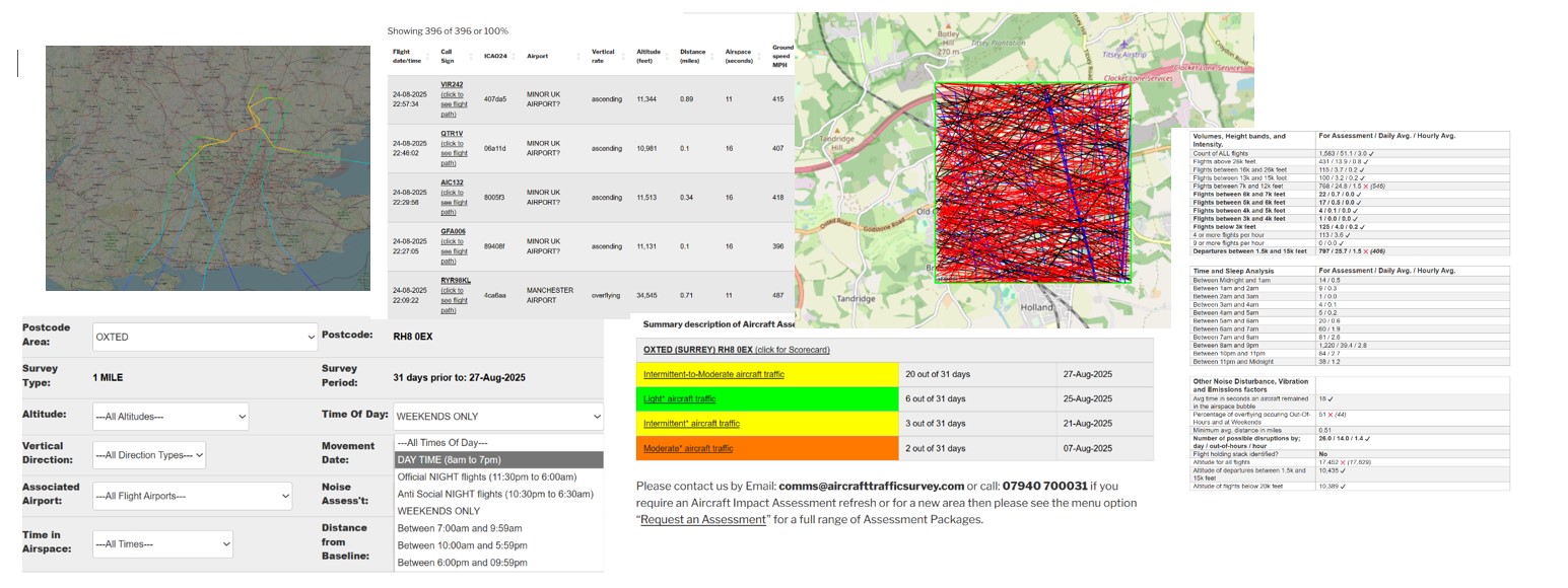
Click to view the on-line Tutorial
31 Day Aircraft Movements – Interactive Analysis
| Flight date sort | Flight date/time | Call Sign | ICAO24 | Airport | Vertical Rate / Compass Direction | Altitude (feet) | Distance (miles) | Airspace (seconds) | Ground speed MPH | xminLatitude | xmaxLatitude | xminlongitude | xmaxlongitude | xCall Sign |
|---|---|---|---|---|---|---|---|---|---|---|---|---|---|---|
| 20240831 | 31-08-2024 23:47:52 | EIN46L (click to see flight path) | 4ca5c8 | TRANSATLANTIC FLIGHT? | overflying ==>North-West<== | 38013 | 0.22 | 15 | 516 | 51.0936 | 51.1068 | -0.242081 | -0.284828 | EIN46L |
| 20240831 | 31-08-2024 01:11:56 | EZY53ZE (click to see flight path) | 4073a0 | BRISTOL AIRPORT | descending ==>West<== | 33123 | 0.5 | 14 | 506 | 51.0997 | 51.1097 | -0.243759 | -0.285263 | EZY53ZE |
| 20240831 | 31-08-2024 01:01:55 | EZY81XF (click to see flight path) | 407796 | BRISTOL AIRPORT | descending ==>North-West<== | 33548 | 0.25 | 15 | 505 | 51.0842 | 51.1026 | -0.247192 | -0.28468 | EZY81XF |
| 20240831 | 31-08-2024 00:41:35 | ABD7264 (click to see flight path) | 4cc54a | TRANSATLANTIC FLIGHT? | overflying ==>East<== | 39000 | 0.33 | 12 | 543 | 51.1015 | 51.1018 | -0.285339 | -0.245285 | ABD7264 |
| 20240830 | 30-08-2024 23:55:51 | EIN549 (click to see flight path) | 4ca770 | TRANSATLANTIC FLIGHT? | overflying ==>North-West<== | 35975 | 0.14 | 14 | 537 | 51.0909 | 51.1066 | -0.241996 | -0.283661 | EIN549 |
| 20240830 | 30-08-2024 05:09:49 | CMB140 (click to see flight path) | a5f11d | TRANSATLANTIC FLIGHT? | overflying ==>East<== | 37000 | 0.56 | 11 | 592 | 51.1047 | 51.1051 | -0.283418 | -0.242145 | CMB140 |
| 20240830 | 30-08-2024 00:26:55 | RYR5YP (click to see flight path) | 4ca264 | TRANSATLANTIC FLIGHT? | overflying ==>North-West<== | 38000 | 0.78 | 9 | 507 | 51.1016 | 51.1111 | -0.241328 | -0.266571 | RYR5YP |
| 20240829 | 29-08-2024 02:18:42 | HLE60 (click to see flight path) | 406f65 | LONDON GATWICK AIRPORT | overflying ==>South-West<== | 1950 | 0.66 | 35 | 158 | 51.1111 | 51.0998 | -0.255508 | -0.286016 | HLE60 |
| 20240828 | 28-08-2024 05:51:31 | AUA94 (click to see flight path) | 440060 | TRANSATLANTIC FLIGHT? | overflying ==>East<== | 37013 | 0.14 | 11 | 567 | 51.0948 | 51.0953 | -0.283279 | -0.243607 | AUA94 |
| 20240828 | 28-08-2024 05:25:45 | DLH411 (click to see flight path) | 3c65ab | TRANSATLANTIC FLIGHT? | overflying ==>East<== | 41000 | 0.13 | 11 | 616 | 51.0951 | 51.0956 | -0.285125 | -0.241477 | DLH411 |
| 20240828 | 28-08-2024 05:12:33 | DLH423 (click to see flight path) | 3c6509 | TRANSATLANTIC FLIGHT? | overflying ==>East<== | 39000 | 0.41 | 11 | 571 | 51.0908 | 51.0914 | -0.284457 | -0.243407 | DLH423 |
| 20240826 | 26-08-2024 04:33:44 | AAL704 (click to see flight path) | aaae4b | TRANSATLANTIC FLIGHT? | overflying ==>East<== | 38000 | 0.1 | 10 | 611 | 51.0959 | 51.0963 | -0.285125 | -0.246524 | AAL704 |
| 20240826 | 26-08-2024 01:38:34 | EXS3KC (click to see flight path) | 400e4a | BRISTOL AIRPORT | overflying ==>North-East<== | 19000 | 0.66 | 13 | 401 | 51.0926 | 51.1108 | -0.285416 | -0.268348 | EXS3KC |
| 20240825 | 25-08-2024 05:25:44 | DAL238 (click to see flight path) | ab8fd0 | TRANSATLANTIC FLIGHT? | overflying ==>East<== | 35000 | 0.08 | 11 | 605 | 51.0954 | 51.096 | -0.284234 | -0.241547 | DAL238 |
| 20240825 | 25-08-2024 00:17:46 | EIN7CG (click to see flight path) | 4ca76f | TRANSATLANTIC FLIGHT? | overflying ==>North-West<== | 35975 | 0.05 | 15 | 497 | 51.0904 | 51.1023 | -0.243378 | -0.286102 | EIN7CG |
| 20240824 | 24-08-2024 23:37:29 | EZY29XZ (click to see flight path) | 40643b | BRISTOL AIRPORT | descending ==>West<== | 33673 | 0.5 | 15 | 494 | 51.0838 | 51.0946 | -0.24292 | -0.285873 | EZY29XZ |
| 20240824 | 24-08-2024 05:57:28 | UAL989 (click to see flight path) | a2b8db | TRANSATLANTIC FLIGHT? | overflying ==>East<== | 36000 | 0.15 | 11 | 626 | 51.0945 | 51.095 | -0.285273 | -0.241852 | UAL989 |
| 20240824 | 24-08-2024 05:54:27 | DLH463 (click to see flight path) | 3c4b28 | TRANSATLANTIC FLIGHT? | overflying ==>East<== | 37000 | 0.78 | 11 | 622 | 51.0853 | 51.086 | -0.284882 | -0.242081 | DLH463 |
| 20240824 | 24-08-2024 05:40:19 | MABRB (click to see flight path) | 424c07 | LONDON STANSTED AIRPORT | ascending ==>South-East<== | 34563 | 0.14 | 17 | 442 | 51.1112 | 51.0839 | -0.277557 | -0.257436 | MABRB |
| 20240824 | 24-08-2024 00:17:07 | EZY81XF (click to see flight path) | 406d95 | BRISTOL AIRPORT | descending ==>North-West<== | 35804 | 0.55 | 12 | 467 | 51.0969 | 51.111 | -0.242996 | -0.272431 | EZY81XF |
| 20240823 | 23-08-2024 05:46:55 | DLH441 (click to see flight path) | 3c4acd | TRANSATLANTIC FLIGHT? | overflying ==>East<== | 36000 | 0.18 | 9 | 659 | 51.099 | 51.0994 | -0.283737 | -0.245337 | DLH441 |
| 20240822 | 22-08-2024 05:23:07 | THY1DP (click to see flight path) | 4bb14a | TRANSATLANTIC FLIGHT? | overflying ==>East<== | 37000 | 0.7 | 11 | 600 | 51.1068 | 51.1071 | -0.285348 | -0.244446 | THY1DP |
| 20240822 | 22-08-2024 00:45:11 | TOM5321 (click to see flight path) | 4072a5 | LONDON LUTON AIRPORT | descending ==>North<== | 26313 | 0.46 | 14 | 509 | 51.0843 | 51.111 | -0.259857 | -0.244598 | TOM5321 |
| 20240820 | 20-08-2024 03:10:01 | TOM9KD (click to see flight path) | 40796c | BRISTOL AIRPORT | descending ==>West<== | 36146 | 0.65 | 13 | 499 | 51.1017 | 51.1109 | -0.242293 | -0.280685 | TOM9KD |
| 20240820 | 20-08-2024 01:38:45 | EXS71DZ (click to see flight path) | 407180 | BRISTOL AIRPORT | descending ==>North-West<== | 33687 | 0.33 | 15 | 515 | 51.0922 | 51.1107 | -0.24147 | -0.280075 | EXS71DZ |
| 20240820 | 20-08-2024 01:01:33 | EZY81XF (click to see flight path) | 407688 | BRISTOL AIRPORT | descending ==>North-West<== | 33716 | 0.84 | 7 | 490 | 51.1022 | 51.1103 | -0.242738 | -0.259857 | EZY81XF |
| 20240820 | 20-08-2024 00:32:04 | TOM649 (click to see flight path) | 4075f4 | BRISTOL AIRPORT | descending ==>North-West<== | 32050 | 0.24 | 16 | 503 | 51.0832 | 51.1029 | -0.244965 | -0.28511 | TOM649 |
| 20240819 | 19-08-2024 05:39:00 | ACA874 (click to see flight path) | c01753 | TRANSATLANTIC FLIGHT? | overflying ==>South-East<== | 37000 | 0.7 | 8 | 640 | 51.0989 | 51.0828 | -0.286387 | -0.26679 | ACA874 |
| 20240818 | 18-08-2024 03:49:43 | TOM7WK (click to see flight path) | 4075f4 | BRISTOL AIRPORT | descending ==>North-West<== | 32584 | 0.25 | 17 | 491 | 51.0907 | 51.111 | -0.241547 | -0.28364 | TOM7WK |
| 20240818 | 18-08-2024 03:44:12 | ADZ762 (click to see flight path) | 452149 | TRANSATLANTIC FLIGHT? | overflying ==>East<== | 37006 | 0.3 | 11 | 580 | 51.0926 | 51.0932 | -0.285199 | -0.244075 | ADZ762 |
| 20240817 | 17-08-2024 05:59:00 | GTI8262 (click to see flight path) | a8699a | TRANSATLANTIC FLIGHT? | overflying ==>East<== | 33025 | 0.1 | 12 | 559 | 51.0956 | 51.0961 | -0.283715 | -0.242367 | GTI8262 |
| 20240816 | 16-08-2024 03:56:45 | AAL293 (click to see flight path) | a9961b | TRANSATLANTIC FLIGHT? | overflying ==>West<== | 34000 | 0.95 | 7 | 487 | 51.107 | 51.1111 | -0.242691 | -0.262756 | AAL293 |
| 20240816 | 16-08-2024 00:16:02 | RRR6229 (click to see flight path) | 43c1c6 | MINOR UK AIRPORT? | descending ==>West<== | 13418 | 0.7 | 17 | 409 | 51.0842 | 51.0893 | -0.242691 | -0.285263 | RRR6229 |
| 20240815 | 15-08-2024 23:50:22 | TOM5EB (click to see flight path) | 407d4c | BRISTOL AIRPORT | descending ==>North-West<== | 33556 | 0.44 | 12 | 511 | 51.0834 | 51.0992 | -0.252609 | -0.284234 | TOM5EB |
| 20240815 | 15-08-2024 00:31:10 | RYR7GQ (click to see flight path) | 4ca7b5 | BRISTOL AIRPORT | descending ==>West<== | 30376 | 0.07 | 18 | 403 | 51.0908 | 51.1013 | -0.242996 | -0.285348 | RYR7GQ |
| 20240814 | 14-08-2024 04:26:47 | ACA832 (click to see flight path) | c04fbb | TRANSATLANTIC FLIGHT? | overflying ==>East<== | 39000 | 0.12 | 12 | 560 | 51.095 | 51.0955 | -0.285051 | -0.241996 | ACA832 |
| 20240814 | 14-08-2024 00:10:51 | TOM51B (click to see flight path) | 407739 | MANCHESTER AIRPORT | overflying ==>South-East<== | 39000 | 0.11 | 16 | 499 | 51.1097 | 51.0827 | -0.280077 | -0.251795 | TOM51B |
| 20240813 | 13-08-2024 05:23:10 | BEL52B (click to see flight path) | 44ccca | TRANSATLANTIC FLIGHT? | overflying ==>East<== | 35975 | 0.27 | 12 | 544 | 51.097 | 51.1043 | -0.285273 | -0.24504 | BEL52B |
| 20240813 | 13-08-2024 05:06:51 | OCN75 (click to see flight path) | 3c15be | TRANSATLANTIC FLIGHT? | overflying ==>East<== | 39000 | 0.79 | 11 | 572 | 51.0852 | 51.0858 | -0.284195 | -0.244668 | OCN75 |
| 20240813 | 13-08-2024 05:01:31 | DLH411 (click to see flight path) | 3c65ac | TRANSATLANTIC FLIGHT? | overflying ==>East<== | 41000 | 0.3 | 10 | 600 | 51.101 | 51.1014 | -0.282156 | -0.244827 | DLH411 |
| 20240813 | 13-08-2024 04:45:22 | BAW58L (click to see flight path) | 40779a | LONDON HEATHROW AIRPORT | descending ==>North-East<== | 8924 | 0.47 | 18 | 372 | 51.0876 | 51.1104 | -0.284976 | -0.264053 | BAW58L |
| 20240813 | 13-08-2024 03:46:30 | FPO7SN (click to see flight path) | 39a203 | TRANSATLANTIC FLIGHT? | descending ==>North-West<== | 37405 | 0.05 | 16 | 478 | 51.0894 | 51.1053 | -0.241776 | -0.284195 | FPO7SN |
| 20240812 | 12-08-2024 05:13:18 | DLH449 (click to see flight path) | 3c64f9 | TRANSATLANTIC FLIGHT? | overflying ==>East<== | 39000 | 0.62 | 11 | 565 | 51.0877 | 51.0883 | -0.284383 | -0.243778 | DLH449 |
| 20240812 | 12-08-2024 01:40:24 | RYR5CH (click to see flight path) | 4ca6fc | LONDON STANSTED AIRPORT | descending ==>North<== | 15573 | 0.48 | 14 | 498 | 51.0831 | 51.111 | -0.25589 | -0.249791 | RYR5CH |
| 20240812 | 12-08-2024 00:39:37 | EXS28Q (click to see flight path) | 407e40 | LONDON STANSTED AIRPORT | descending ==>North<== | 18342 | 0.4 | 16 | 419 | 51.0838 | 51.1103 | -0.257362 | -0.251617 | EXS28Q |
| 20240809 | 09-08-2024 23:56:27 | EIN549 (click to see flight path) | 4ca76f | TRANSATLANTIC FLIGHT? | overflying ==>North-West<== | 36000 | 0.77 | 10 | 456 | 51.1016 | 51.111 | -0.241922 | -0.267029 | EIN549 |
| 20240809 | 09-08-2024 23:38:55 | MABRB (click to see flight path) | 424c07 | LONDON STANSTED AIRPORT | ascending ==>South<== | 33442 | 0.74 | 9 | 539 | 51.1018 | 51.0836 | -0.284976 | -0.273743 | MABRB |
| 20240808 | 08-08-2024 05:15:17 | CFG2075 (click to see flight path) | 3c7a4a | TRANSATLANTIC FLIGHT? | overflying ==>East<== | 40000 | 0.1 | 11 | 609 | 51.0954 | 51.0959 | -0.285273 | -0.242233 | CFG2075 |
| 20240808 | 08-08-2024 01:14:46 | EZY36DR (click to see flight path) | 40756a | BRISTOL AIRPORT | descending ==>North-West<== | 34964 | 0.25 | 17 | 460 | 51.0834 | 51.1028 | -0.245337 | -0.284729 | EZY36DR |
| 20240807 | 07-08-2024 23:57:26 | IFA1233 (click to see flight path) | 3cd70e | TRANSATLANTIC FLIGHT? | overflying ==>South-East<== | 37005 | 0.6 | 12 | 561 | 51.1114 | 51.087 | -0.259218 | -0.241547 | IFA1233 |
| 20240807 | 07-08-2024 05:22:00 | UAL989 (click to see flight path) | a1f2b1 | TRANSATLANTIC FLIGHT? | overflying ==>East<== | 35000 | 0.37 | 11 | 595 | 51.0914 | 51.0919 | -0.282974 | -0.241623 | UAL989 |
| 20240807 | 07-08-2024 00:54:17 | EZY67BV (click to see flight path) | 407eec | LONDON GATWICK AIRPORT | overflying ==>South<== | 3029 | 0.5 | 25 | 258 | 51.1102 | 51.0867 | -0.255061 | -0.241996 | EZY67BV |
| 20240806 | 06-08-2024 23:34:48 | N103WG (click to see flight path) | a011d4 | LONDON LUTON AIRPORT | overflying ==>East<== | 45000 | 0.16 | 10 | 604 | 51.0944 | 51.0948 | -0.280609 | -0.252166 | N103WG |
| 20240806 | 06-08-2024 05:41:20 | AUA94 (click to see flight path) | 440060 | TRANSATLANTIC FLIGHT? | overflying ==>East<== | 37000 | 0.46 | 12 | 565 | 51.1034 | 51.1038 | -0.284348 | -0.241699 | AUA94 |
| 20240806 | 06-08-2024 02:26:36 | EZY41ZR (click to see flight path) | 405f12 | LONDON LUTON AIRPORT | descending ==>North<== | 25233 | 0.49 | 13 | 509 | 51.083 | 51.1098 | -0.278702 | -0.271912 | EZY41ZR |
| 20240806 | 06-08-2024 00:50:51 | EXS64RW (click to see flight path) | 407031 | LONDON STANSTED AIRPORT | descending ==>North<== | 22171 | 0.53 | 13 | 501 | 51.084 | 51.1102 | -0.254288 | -0.248529 | EXS64RW |
| 20240806 | 06-08-2024 00:09:39 | RUK1203 (click to see flight path) | 407cb4 | LONDON STANSTED AIRPORT | descending ==>North<== | 21750 | 0.77 | 16 | 430 | 51.083 | 51.1104 | -0.285273 | -0.278015 | RUK1203 |
| 20240805 | 05-08-2024 23:49:00 | EZY36DR (click to see flight path) | 4078ef | BRISTOL AIRPORT | descending ==>North-West<== | 31812 | 0.32 | 12 | 522 | 51.0858 | 51.1011 | -0.252762 | -0.284424 | EZY36DR |
| 20240804 | 04-08-2024 03:02:50 | UAF1301 (click to see flight path) | 896c3b | TRANSATLANTIC FLIGHT? | overflying ==>South-East<== | 35000 | 0.55 | 11 | 602 | 51.1106 | 51.0904 | -0.263152 | -0.242233 | UAF1301 |
| 20240804 | 04-08-2024 01:36:31 | EZY12DN (click to see flight path) | 407796 | BRISTOL AIRPORT | descending ==>West<== | 32318 | 0.3 | 18 | 403 | 51.087 | 51.0975 | -0.243035 | -0.284882 | EZY12DN |
| 20240803 | 03-08-2024 01:12:50 | RYR1315 (click to see flight path) | 4ca301 | BRISTOL AIRPORT | descending ==>North-West<== | 33543 | 0.78 | 10 | 408 | 51.1013 | 51.111 | -0.243258 | -0.263824 | RYR1315 |
| 20240803 | 03-08-2024 00:36:25 | EZY53ZE (click to see flight path) | 407794 | BRISTOL AIRPORT | descending ==>West<== | 29736 | 0.59 | 17 | 419 | 51.101 | 51.1106 | -0.241699 | -0.284653 | EZY53ZE |
| 20240803 | 03-08-2024 00:27:30 | EZY43DT (click to see flight path) | 406755 | BRISTOL AIRPORT | descending ==>West<== | 34957 | 0.46 | 16 | 445 | 51.0853 | 51.0941 | -0.241477 | -0.284119 | EZY43DT |
| 20240801 | 01-08-2024 02:29:21 | BCS2581 (click to see flight path) | 440bcf | LONDON LUTON AIRPORT | ascending ==>South-East<== | 24925 | 0.72 | 10 | 483 | 51.1104 | 51.0967 | -0.259476 | -0.242738 | BCS2581 |
| 20240801 | 01-08-2024 01:30:53 | TOM561 (click to see flight path) | 408040 | TRANSATLANTIC FLIGHT? | overflying ==>North-West<== | 36000 | 0.37 | 14 | 506 | 51.0939 | 51.1105 | -0.243555 | -0.278244 | TOM561 |
| 20240731 | 31-07-2024 01:28:33 | RYR61WB (click to see flight path) | 4cadbd | LONDON STANSTED AIRPORT | descending ==>North<== | 15070 | 0.45 | 16 | 442 | 51.0828 | 51.1111 | -0.277786 | -0.270309 | RYR61WB |