Click to view the on-line Tutorial
31 Day Aircraft Movements – Interactive Analysis
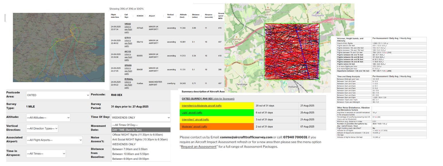
| Flight date sort | Flight date/time | Call Sign | ICAO24 | Airport | Vertical Rate / Compass Direction | Altitude (feet) | Distance (miles) | Airspace (seconds) | Ground speed MPH | xminLatitude | xmaxLatitude | xminlongitude | xmaxlongitude | xCall Sign |
|---|---|---|---|---|---|---|---|---|---|---|---|---|---|---|
| 20221014 | 14-10-2022 05:32:24 | UAL950 (click to see flight path) | a21633 | NON UK AIRPORT | overflying ==>East<== | 35000 | 0.29 | 10 | 689 | 51.3012 | 51.3015 | -2.60231 | -2.56264 | UAL950 |
| 20221008 | 08-10-2022 00:06:52 | EZY57XV (click to see flight path) | 406544 | MINOR UK AIRPORT? | descending ==>North<== | 5123 | 0.66 | 22 | 248 | 51.2871 | 51.3079 | -2.59775 | -2.59537 | EZY57XV |
| 20221007 | 07-10-2022 23:38:50 | RYR93YG (click to see flight path) | 4ca73b | MINOR UK AIRPORT? | descending ==>North<== | 6791 | 0.08 | 25 | 283 | 51.2836 | 51.311 | -2.58392 | -2.58247 | RYR93YG |
| 20221006 | 06-10-2022 00:53:26 | EZY57XV (click to see flight path) | 4010ee | BRISTOL AIRPORT | descending ==>North-East<== | 4746 | 0.17 | 24 | 287 | 51.2841 | 51.305 | -2.58644 | -2.56263 | EZY57XV |
| 20221003 | 03-10-2022 05:04:41 | UAL884 (click to see flight path) | a2a2e3 | NON UK AIRPORT | overflying ==>North-East<== | 40986 | 0.63 | 9 | 625 | 51.2847 | 51.2936 | -2.60279 | -2.5737 | UAL884 |
| 20221001 | 01-10-2022 00:42:49 | RYR6PA (click to see flight path) | 4ca850 | MINOR UK AIRPORT? | descending ==>North<== | 7345 | 0.53 | 21 | 301 | 51.2846 | 51.3083 | -2.59426 | -2.59285 | RYR6PA |
| 20220929 | 29-09-2022 04:10:12 | SWR87 (click to see flight path) | 4b187f | NON UK AIRPORT | overflying ==>North-East<== | 39000 | 0.07 | 13 | 588 | 51.2913 | 51.3031 | -2.60201 | -2.56401 | SWR87 |
| 20220928 | 28-09-2022 04:15:17 | SWR87 (click to see flight path) | 4b187d | NON UK AIRPORT | overflying ==>North-East<== | 39006 | 0.57 | 9 | 610 | 51.3004 | 51.3092 | -2.59064 | -2.56256 | SWR87 |
| 20220928 | 28-09-2022 03:31:26 | TOM2HY (click to see flight path) | 406d70 | MINOR UK AIRPORT? | descending ==>East<== | 5368 | 0.06 | 25 | 281 | 51.2942 | 51.2981 | -2.6033 | -2.5605 | TOM2HY |
| 20220928 | 28-09-2022 03:20:20 | NPT05K (click to see flight path) | 40676f | EXETER INTERNATIONAL AIRPORT | overflying ==>North-East<== | 17000 | 0.7 | 12 | 448 | 51.2965 | 51.3115 | -2.60354 | -2.58301 | NPT05K |
| 20220927 | 27-09-2022 23:41:41 | RYR1YZ (click to see flight path) | 4ca805 | BRISTOL AIRPORT | descending ==>East<== | 5971 | 0.85 | 13 | 294 | 51.308 | 51.3106 | -2.59582 | -2.57355 | RYR1YZ |
| 20220925 | 25-09-2022 03:30:41 | AXY994S (click to see flight path) | 4d2230 | NON UK AIRPORT | overflying ==>North-East<== | 39000 | 0.43 | 13 | 508 | 51.2862 | 51.2958 | -2.60162 | -2.56627 | AXY994S |
| 20220922 | 22-09-2022 23:34:47 | EZY86CZ (click to see flight path) | 406016 | BRISTOL AIRPORT | descending ==>North-East<== | 5346 | 0.57 | 24 | 286 | 51.2913 | 51.3105 | -2.60198 | -2.57439 | EZY86CZ |
| 20220922 | 22-09-2022 00:55:26 | EZY6076 (click to see flight path) | 406a91 | BRISTOL AIRPORT | descending ==>East<== | 5115 | 0.33 | 26 | 268 | 51.2991 | 51.3047 | -2.60376 | -2.56172 | EZY6076 |
| 20220921 | 21-09-2022 23:35:17 | RYR1Q (click to see flight path) | 4ca90f | BRISTOL AIRPORT | descending ==>North-East<== | 5393 | 0.84 | 17 | 235 | 51.2837 | 51.296 | -2.57303 | -2.55882 | RYR1Q |
| 20220921 | 21-09-2022 05:47:22 | N151QS (click to see flight path) | a0cf55 | NON UK AIRPORT | overflying ==>East<== | 43000 | 0.06 | 13 | 571 | 51.2928 | 51.3008 | -2.60254 | -2.55944 | N151QS |
| 20220917 | 17-09-2022 03:11:54 | EZY93QH (click to see flight path) | 40768d | BRISTOL AIRPORT | descending ==>North-East<== | 5090 | 0.59 | 22 | 252 | 51.284 | 51.2956 | -2.5882 | -2.55989 | EZY93QH |
| 20220917 | 17-09-2022 02:16:47 | EXS9FB (click to see flight path) | 4070e1 | BRISTOL AIRPORT | descending ==>East<== | 5584 | 0.96 | 8 | 287 | 51.3096 | 51.3114 | -2.59285 | -2.58082 | EXS9FB |
| 20220915 | 15-09-2022 01:31:23 | EZY6062 (click to see flight path) | 4074b2 | BRISTOL AIRPORT | descending ==>East<== | 9260 | 0.45 | 20 | 314 | 51.2892 | 51.2921 | -2.5988 | -2.56093 | EZY6062 |