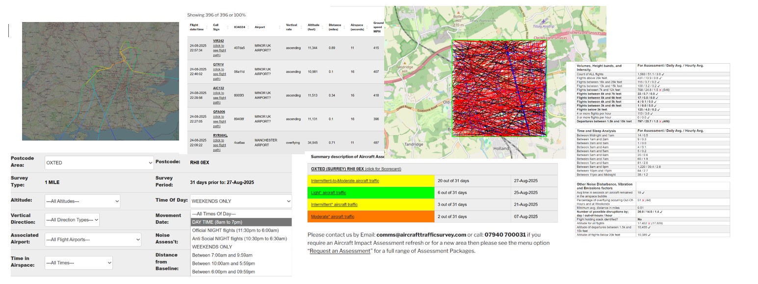
Click to view the on-line Tutorial
31 Day Aircraft Movements – Interactive Analysis
| Flight date sort | Flight date/time | Call Sign | ICAO24 | Airport | Vertical Rate / Compass Direction | Altitude (feet) | Distance (miles) | Airspace (seconds) | Ground speed MPH | xminLatitude | xmaxLatitude | xminlongitude | xmaxlongitude | xCall Sign |
|---|---|---|---|---|---|---|---|---|---|---|---|---|---|---|
| 20251123 | 23-11-2025 05:27:49 | UAL52 (click to see flight path) | a86ab5 | TRANSATLANTIC FLIGHT? | overflying ==>South-East<== | 37015 | 0.09 | 16 | 617 | 50.8241 | 50.7963 | -0.519921 | -0.476074 | UAL52 |
| 20251123 | 23-11-2025 04:46:50 | UAL956 (click to see flight path) | a8a87e | TRANSATLANTIC FLIGHT? | overflying ==>South-East<== | 37000 | 0.37 | 12 | 616 | 50.8124 | 50.7962 | -0.518139 | -0.478945 | UAL956 |
| 20251123 | 23-11-2025 04:14:52 | UAL40 (click to see flight path) | aa44ad | TRANSATLANTIC FLIGHT? | overflying ==>South-East<== | 35000 | 0.63 | 8 | 635 | 50.8241 | 50.8119 | -0.502921 | -0.477676 | UAL40 |
| 20251123 | 23-11-2025 03:54:28 | DAL182 (click to see flight path) | a4eacb | TRANSATLANTIC FLIGHT? | overflying ==>South-East<== | 39007 | 0.42 | 12 | 593 | 50.8119 | 50.7964 | -0.519327 | -0.481543 | DAL182 |
| 20251121 | 21-11-2025 05:50:32 | TRA5641 (click to see flight path) | 4866df | TRANSATLANTIC FLIGHT? | overflying ==>South-West<== | 34025 | 0.27 | 13 | 615 | 50.8238 | 50.8052 | -0.479813 | -0.520935 | TRA5641 |
| 20251117 | 17-11-2025 04:00:44 | AFR1M (click to see flight path) | 394a01 | TRANSATLANTIC FLIGHT? | overflying ==>South-East<== | 39000 | 0.61 | 10 | 590 | 50.8088 | 50.7965 | -0.520706 | -0.488817 | AFR1M |
| 20251115 | 15-11-2025 02:07:31 | HYP247 (click to see flight path) | 4d21bc | FARNBOROUGH AIRPORT | descending ==>North<== | 28123 | 0.58 | 13 | 553 | 50.7963 | 50.8244 | -0.518112 | -0.506262 | HYP247 |
| 20251113 | 13-11-2025 05:52:56 | RRR6166 (click to see flight path) | 43c174 | TRANSATLANTIC FLIGHT? | ascending ==>South-East<== | 27790 | 0.15 | 18 | 474 | 50.8237 | 50.7971 | -0.519562 | -0.485611 | RRR6166 |
| 20251112 | 12-11-2025 05:49:17 | RRR6136 (click to see flight path) | 43c173 | TRANSATLANTIC FLIGHT? | ascending ==>South-East<== | 30304 | 0.05 | 17 | 503 | 50.8243 | 50.7969 | -0.517322 | -0.482483 | RRR6136 |
| 20251103 | 03-11-2025 05:06:37 | UAL57 (click to see flight path) | aaa893 | TRANSATLANTIC FLIGHT? | overflying ==>South-East<== | 35000 | 0.08 | 13 | 623 | 50.8194 | 50.8024 | -0.520292 | -0.477066 | UAL57 |
| 20251102 | 02-11-2025 23:42:11 | EZY58DK (click to see flight path) | 407f67 | LONDON GATWICK AIRPORT | descending ==>North-East<== | 9233 | 0.1 | 23 | 349 | 50.7999 | 50.8177 | -0.519327 | -0.477753 | EZY58DK |
| 20251102 | 02-11-2025 01:48:34 | EZY8054 (click to see flight path) | 406753 | LONDON GATWICK AIRPORT | descending ==>North-East<== | 12515 | 0.54 | 14 | 432 | 50.7967 | 50.8089 | -0.512314 | -0.478054 | EZY8054 |
| 20251031 | 31-10-2025 00:08:19 | EZY14DB (click to see flight path) | 405637 | LONDON LUTON AIRPORT | descending ==>North<== | 24810 | 0.53 | 13 | 526 | 50.7978 | 50.8244 | -0.516283 | -0.505066 | EZY14DB |
| 20251030 | 30-10-2025 05:13:32 | APK7578 (click to see flight path) | 064227 | LONDON GATWICK AIRPORT | descending ==>North-East<== | 10008 | 0.35 | 22 | 352 | 50.7973 | 50.8122 | -0.520217 | -0.477311 | APK7578 |
| 20251030 | 30-10-2025 00:59:07 | RUK3KQ (click to see flight path) | 407f0e | LONDON STANSTED AIRPORT | descending ==>North<== | 30719 | 0.9 | 11 | 385 | 50.8085 | 50.8243 | -0.520663 | -0.51384 | RUK3KQ |
| 20251029 | 29-10-2025 05:35:00 | UAL134 (click to see flight path) | a8e4e9 | TRANSATLANTIC FLIGHT? | overflying ==>South-East<== | 39004 | 0.21 | 14 | 575 | 50.816 | 50.7984 | -0.519995 | -0.478202 | UAL134 |
| 20251027 | 27-10-2025 02:34:30 | EXS14K (click to see flight path) | 4077bb | LONDON STANSTED AIRPORT | descending ==>North<== | 29652 | 0.26 | 15 | 456 | 50.7971 | 50.8233 | -0.497818 | -0.487258 | EXS14K |
| 20251026 | 26-10-2025 02:14:48 | EZY85QZ (click to see flight path) | 408051 | LONDON LUTON AIRPORT | descending ==>North<== | 24820 | 0.96 | 9 | 380 | 50.7972 | 50.8102 | -0.481023 | -0.476074 | EZY85QZ |
| 20251026 | 26-10-2025 01:50:18 | EDC644 (click to see flight path) | 407446 | LONDON LUTON AIRPORT | descending ==>North<== | 24940 | 0.06 | 16 | 419 | 50.7979 | 50.824 | -0.502625 | -0.49202 | EDC644 |
| 20251026 | 26-10-2025 01:01:08 | TOM43G (click to see flight path) | 4080cf | LONDON GATWICK AIRPORT | descending ==>North-East<== | 12178 | 0.62 | 16 | 384 | 50.8138 | 50.825 | -0.519846 | -0.485032 | TOM43G |