Fact 1: Aircraft noise in the UK is NOT recognised as a statutory nuisance. This means there is no legal support should you unexpectedly buy a home in a UK postcode blighted by aircraft noise. Not only that, but it’s highly likely aircraft noise will worsen as airport usage in the UK expands, with the planned introduction of commercial drones.
Fact 2: All aircraft create noise and emit toxic carbon pollutants. Too much noise and a too bigger concentration of toxic air pollutants has serious health issues in terms of our sleep deprivation and air quality. In the UK we have Environmental and Noise regulations i.e. laws, which are designed to control both noise and air quality created by our; industries, SMEs businesses and also our neighbours. HOWEVER, the Aviation sector has exemptions from the regulation.
Fact 3: The result of these exemptions means our local and district councils aren’t officially allowed to directly report or comment on Aircraft nuisance, i.e. it’s not a property Search consideration. This Website is designed to plug that gap and provide everyone with a shared understanding by providing access to our 2 Minute Aircraft Assessment.
There are two distinct types of aircraft noise that affect the majority of people. The first type is a roar that typically occurs within 2-4 miles around an airport and is often associated with planes taking-off. However this type of noise is going to be obvious to detect when visiting the local area as the planes will be very visible, often below 5k feet.
The second type of noise is what we term as a constant whine or droning sound that can occur anywhere within UK airspace. However, some UK postcodes are much more exposed than others as you will see from the information provided on this website.
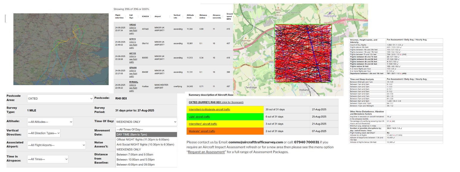
Our Aircraft Noise Facts, Figures and Assessments website is designed to help you make an informed decision about the postcodes that meet your noise nuisance criteria. The raw aircraft movement data used by our Assessment algorithms is kindly provided by the Opensky Network Org. which is an Open Data aircraft research community whose stakeholders and sponsors includes the likes of Oxford University and EuroControl.
Let’s get started by using our existing free community Aircraft noise Assessments.
Our approach to aircraft noise monitoring doesn’t rely on expensive, passive analogue monitoring stations that often require planning and approval by the aviation industry. Instead we use dynamic algorithms and real aircraft movement “open data” to create virtual aircraft noise monitor stations. This provides us with the flexibility, affordability and mobility required, without any need for planning.
We passionately believe we have the right to know the consequences of the Aviation sector’s actions within our airspace, the airspace in which we share, breathe and bring up our families.
It’s also a fact our small UK island is the home to one of world’s most densely and largest aviation networks, based on land mass, and it’s growing. Growth has implications on our UK cities, towns and villages when deciding where we live, work, holiday or retire to.